


 text new page (beta)
 English (pdf)
 Article in xml format
 Article references
 Send this article by e-mail
 Cited by SciELO
  Similars in
SciELO
Similars in
SciELO 
 Permalink
Introduction
The isotope radon (222 Rn), hereafter simply referred to as radon, is a daughter nuclide of radium (226Ra), which in turn is produced through the radioactive decay series of uranium (238U). As a naturally occurring radioactive gas with half-life of 3.82 days, radon is widely used as a sensitive tracer in various fields of earth sciences. Common radon applications include monitoring of seismic activities (Al-Hilal et al. 1998; Yasuoka et al. 2006; Ghosh et al. 2009); detecting hidden faults (Baubron et al. 2002; Neri et al. 2016; Al -Hilal, 2016); uranium exploration (Gingrich, 1984; Jubeli et al. 2000). Moreover, radon has been repeatedly raised through numerous studies in the last decades as a preferable natural tracer for undertaking a wide range of issues regarding environmental and hydrogeological researches (Hoehn and von Gunten, 1989; Schubert et al. 2006; Murray Close et al. 2014; Faten Telahigue et al. 2018). In fact, the application of radon as a tracer for evaluating surface-groundwater interaction is particularly important in cases involving karst aquifer systems (Eisenlohr and Surbeck, 1995; Monnin and Seidel, 2002). This is because of the high transmissibility and permeability of the karst complexes due to the dissolution of soluble bedrock which commonly results in the occurrence of distinct physiographic features such as caves, fissured layers and the issues of large karst springs. Karstification is generally defined as a unique hydrogeologic terrain in which the surface water and groundwater systems are highly interconnected, due to water dissolving the limestone rocks and so the formation of networks of solution cavities (El-Hakim and Bakalowicz 2007). In view of that, the development of karst systems would not only enhance the processes of fluid infiltration, but also it may provide the necessary pathways for significant bulk flow of soil gas to migrate over great horizontal and vertical distances. With reference to our study region, there is an intensive development of karst in thick bedded carbonate strata of the upper Cretaceous aquifer throughout the recharge area of the Barada River. Additionally, upper Quaternary fluvial-alluvial aquifer type with variable thickness has been developed throughout the riparian margins of the Barada River. The Barada River receives most of its water from the Anti-Lebanon Mountains, where it is mainly fed by karst reservoirs of Jurassic and upper Cretaceous aquifers. However, the river has suffered from severe drought and pollution in the last decades, mainly due to the lower rainfall rates and the large increase in population growth in the area. Hence, the potable aquifers adjoining and underlying the course of the Barada River may possibly become vulnerable to a risk of environmental contamination, due to river water infiltration to the nearby aquifers. Previous detailed studies have included extensive surface geological mapping, structural surveys, and a hydrogeologic assessment of the available water resources in the Damascus basin and Figeh spring (La-Moreaux et al. 1989). Moreover, a characterization of the groundwater in the major karst springs throughout the Damascus aquifer systems, using chemical and environmental isotope techniques was completed by Kattan (1997). Further investigations for the evaluation of water resources in the Damascus Ghotta basin, by using hydrochemical and environmental isotope methods (18O, 2H and tritium), were performed by Kattan (2006). However, considering the significance of the Barada River as a major hydrological component of the Damascus basin, more studies are imperatively required to address the water quality issue, and to assess the risk of pollution that might be caused by water infiltration from the river. Radon as a potential tracer may present additional data regarding the mechanism of groundwater percolation through the aquifer system, and thereby provide information on the hydrogeological characteristics of the subsurface structures. The location of the present study represents a small sector known locally as "Rabwe site", which lies over fluvial sediments deposited along the margins of the Barada River, about 5 km from the entrance of Damascus city where it is entirely surrounded by Mount Qassion (Figures 1 and 2). Accordingly, the primary goal of this work is to investigate the possibility of using radon as a promising tool for assessing infiltration from surface waters of the Barada River to the neighboring aquifers.
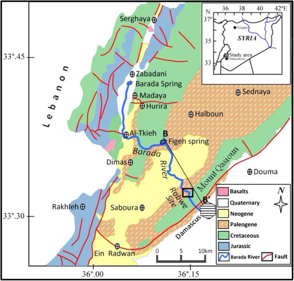
Figure 1 A geological map of Wadi Barada showing the trend of the Barada River, NW of Damascus. The rectangle indicates the location of the present study at Rabwe site; the line B-B' is the location of the geological cross-section.

The study area
Morphology and climate
The so called "Wadi or Barada Valley" represents a significant sector of the Damascus basin, that is located northwest of Damascus city, between latitudes of 33°.30'-33°.45'N and longitudes of 36°.00'-36°.20'E (Fig. 1). The valley comprises three major hydrological components, including the Barada River, as well as the Barada and Figeh karst springs that flow from a remarkable karstified terrain and supply the Barada River with water throughout the year. At present, Wadi Barada is the home of 17 towns, and it is famous for being a distinct mountainous area hosting the Barada River, which flows over a distance of ~ 65km, from the Zabadani valley in NW Damascus to the Ghotta plain in the eastern margin of the city. The river descends within Wadi Barada, where it flows through a highly cultivated and populated hilly area, and just before it arrives at Damascus, it passes through a narrow gorge with a very interesting sight named the"Rabwe site", where the present study is taking place (Fig. 2). The diversity of geomorphology characteristics in the region is quite variable, including the occurrences of irregular uplifts, hogbacks and valleys along with compressive folding and faulting, resulting in various morphological features, most notably Mount Qasioun and the Rabwe site.
The climate of the Damascus region is generally Mediterranean, continental to semi-arid type. It is commonly marked by cold humid winters and hot dry summers, with relatively short spring and autumn seasons. The air temperature decreases usually during the winter season to less than 0°C within high altitude areas, and may reach more than 42°C during summer time. Rainfall occurs only during the rainy season (November-April), and snowfall occurs mostly in the high mountainous regions (≥ 1500 m a.s.l.). The average values of annual precipitation are ~600 mm in Bloudan (~30 km NW of Damascus), and ~200 mm at the Damascus meteorological station. However, decreasing precipitation trends observed throughout the region, together with recent drought periods have led to a notable drop in the karstic spring discharge, and thereby increased concerns about water availability and potability under changing future climate conditions (Abou Zakhem and Kattaa 2016).
Geology and hydrogeology
The geology of Wadi Barada involves a broad stratigraphic succession of sedimentary rocks, beginning with the Jurassic up to Quaternary and recent formations (Fig. 3). The Quaternary deposits are commonly developed in depressions and along the margins of streams and riverbanks, and they consist mainly of alluvium, fluvial gravels, sandy loam, silt, and clays. The underlying Neogene (Pliocene) formations are basically composed of various series of conglomerates, sands and silts. The Paleogene (Eocene) is characterized by chalky limestone, calcareous marls and flints, and it is extensively outcropped on the flanks of Mount Qasioun. The upper Cretaceous unit (Cenomanian-Turonian) is widely outcropped in the catchment recharge area of Figeh spring, where it is recognized by thick bedded strata (~720m) of karstified limestone and dolomite rocks. This unit is distinguished by the development of intensive Karst features such as solution pits, caves and fissured layers with high water capacity, so it is considered as the groundwater-bearing reservoir having the greatest potential in the Damascus basin (Ponikarov 1967; La-Moreaux et al.1989).
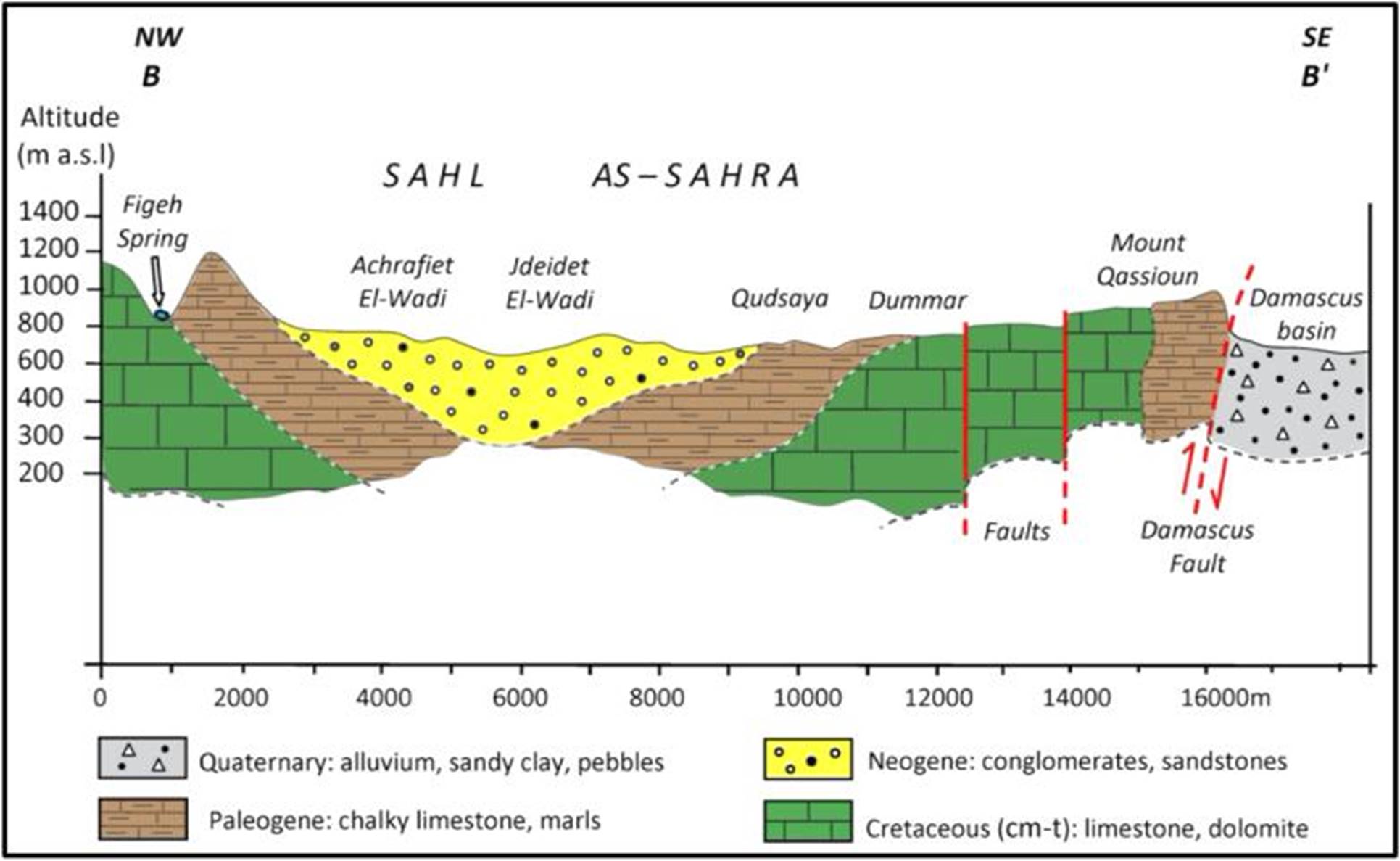
Figure 3 A geological cross-section (B-B') through the main geological units in the study region, see figure 1 for location.
From the hydrogeological point of view, the upper Cretaceous and the Quaternary aquifer systems are of particular importance because of their high transmissibility and permeability characteristics. The upper Cretaceous complex can be characterized as a high potential groundwater resource for a number of vital permanent springs and wells in the region with a high discharge (Al-Charideh, 2012). The Quaternary fluvial-alluvial aquifer is mostly located in low lands and extends along the margins of the Barada River where it is recharged primarily by infiltration from the surface water of the river. As mentioned previously, the Barada River is mainly fed by the groundwater of two enduring karst springs flowing from the Anti-Lebanon Mountains in southwestern Syria. The first is known as Barada spring that issues from thick karstified carbonate strata of the upper Jurassic aquifer with average long-term discharge rate of ~2.5 m3/s. The second is named Figeh spring, which emerges from thick layers of highly karstified limestone and dolomites of the upper Cretaceous aquifer, with an average long-term discharge rate of ~7.7 m3/s (Al-Charideh, 2011). Although both springs are considered vital groundwater resources, the Figeh spring is unique in being the groundwater reservoir with the highest potential in the Damascus basin, which provides most of potable water supply for Damascus city and its suburbs. Additionally, the groundwater of major karst springs emerging from the Anti-Lebanon Mountains are mainly originated from direct infiltration of meteoric precipitation in the exposure zones (Kattan, 1997). However, the water quality of the Barada River is generally impure, brackish, less saline upstream but becoming progressively more saline as the river flows through the lands downstream. Thus, the salinity level of the Barada River water is commonly consistent with those of arid and semi-arid rivers (Kattan, 2006).
Materials and methodology
The main advantages of using the radon method as an adequate tool in various geological and hydrological studies are (1) the relatively low-cost and simplicity of conducting radon measurements in both soil gas and groundwater, (2) the results are immediately available, and (3) the avoidance of any synthetic tracer injection into the water of the aquifer. However, there is always a probability for some errors associated with radon measurements. Among the most common causes of radon errors are probably the sensitivity of radon gas and its ability to escape to the atmosphere.; the variability in the rate of radon degassing; and the relatively short half-life of radon as it could sometimes be dispersed before it reaches the surface. Therefore, radon in hydrogeological studies is usually used as tracer element (Eisenlohr and surbeck, 1995; Schubert et al. 2006). In view of that, the personal experience in the fieldwork is important, as well the accuracy of the device and the quality of its performance are significant. However, the multiple measurements of samples from the same point could sufficiently minimize the possible occurrence of errors. In the present study, the measurement of radon concentration in water was performed by using a portable AlphaGUARD PQ2000 Pro radon monitor. The instrument is equipped with an (ionization chamber) detector with a detection limit of 2-2000.000 Bq.m-3. The system consists of the AlphaGUARD detector along with an automatic pump and degassing unit with some other external accessories for setting up the AquaKIT measurement. In practice, at each operational measurement, a 100 ml water sample is carefully transferred into the degassing unit and the measurement process is properly started. The gas is bubbled and automatically drawn from the water sample into the ionization chamber with a steady continuous pumping rate of 0.3L/min. As radon activity usually shows initial growth before it stabilizes at each sampling point, the radon concentrations were registered in 10-min intervals over about a one-hour period. Consequently, based on multiple measurements, an average value of radon concentration in groundwater is determined in (Bq.m−3) with fairly good confidence. One point of importance in the AlphaGUARD instrument is that each displayed value of radon concentration is followed by its appropriate statistical error value. Accordingly, the set of our radon data was statistically analyzed, and the overall error was estimated to be in the order of ±17%.
The principle of using radon as a natural tracer to estimate both the residence time of riverbank infiltrated water and its infiltration velocity is based on the fact that surface water initially contains a low radon concentration. This is because turbulent currents cause the gas to escape (Fig. 4). However, the radon concentration starts to accumulate as water flows through the sediments of the aquifer, so that equilibrium between radon buildup and the rate of radioactive decay is achieved.
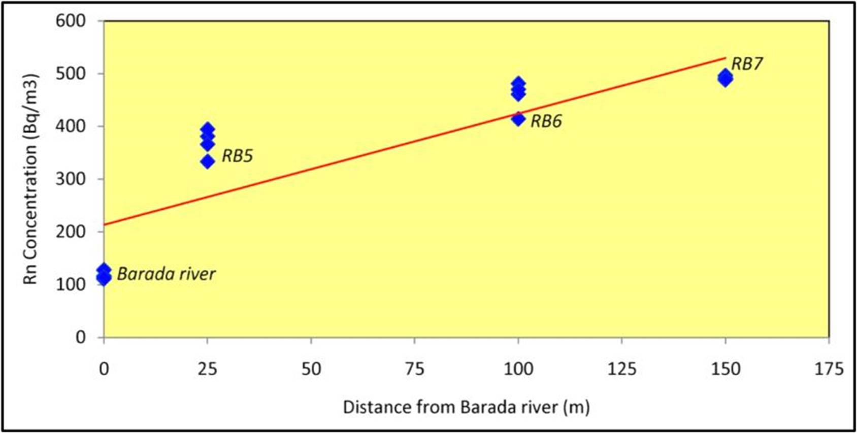
Figure 4 Increasing radon concentration in groundwater with increasing distance from the main channel of the Barada River, (RB indicates the observation wells).
The increase in radon activity (At) as a function of the time (t) until reaching a state of equilibrium (Ae) can be described by the standard growth law of radioactivity as follows:
Where:
(At) is the radon activity in groundwater measured at the time (t),
(Ae) is the radon activity in groundwater at equilibrium,
(λ) is the radioactive decay constant of radon-222 (λRn꞊ 0.1813 d-1).
From equation 1, it can be shown that the ingrowth of radon activity will reach 42%, 72%, 92% and 98% of the equilibrium radon value after 3, 7, 14 and 21days, respectively (Fig. 5). This provides a sufficient window of almost two weeks as travel time for groundwater with radon concentration ingrowth that may eventually give useful information on groundwater recharge characteristics.
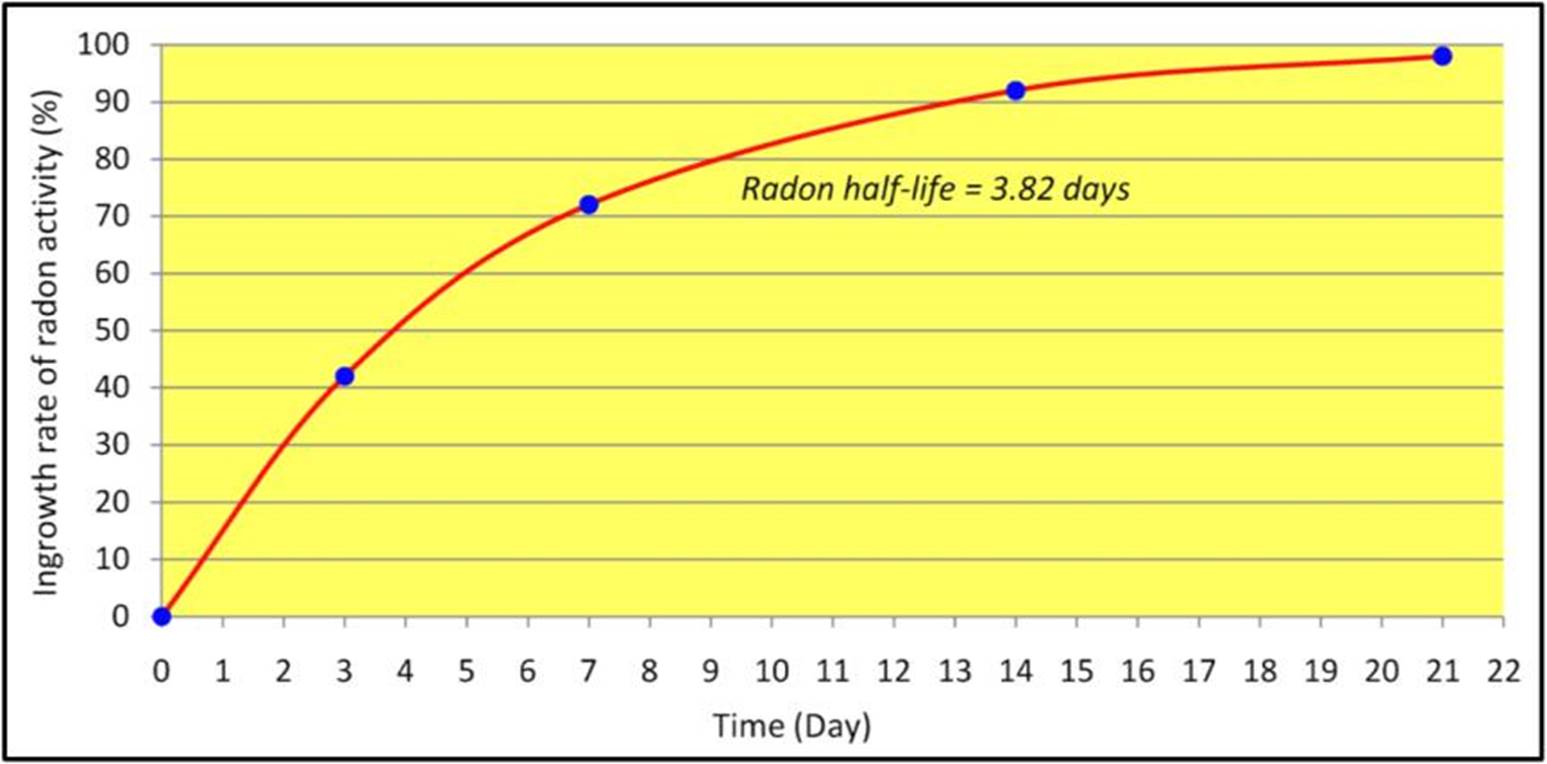
Figure 5 Ingrowth rate of radon activity in a closed system until it reaches an equilibrium value in approximately 6 half-lives (~22.9 days).
According to equation 1, the residence time of the infiltrating river water could be calculated using the following equation:
However, this requires knowledge of the equilibrium radon activity (Ae) in groundwater unaffected by the infiltrating surface water. Hence, this parameter was determined by measuring radon activity in the groundwater of well (RB8) where radon is considered at a state of equilibrium, because the well is located at a sufficient distance away from the influence of the Barada River, so its water level was constant with no water inputs for at least one month.
If taking into consideration the radon activity (Ao) at the time (to) of the river water, and residence time (tres꞊t-to), equation (2) can be adapted as follows, to calculate the residence time of groundwater (tres) which filtrates from the riverbank to the nearby aquifer:
Results and discussion
Extensive field geological investigations and monitoring of spatial groundwater radon variations were carried out in the study area during the spring season in 2018, using AlphaGUARD radon monitor. Four pre-existing wells, denoted as RB5, RB6, RB7 and RB8, were selected for achieving the purpose of this study. The observation wells were drilled in Quaternary fluvial-alluvial formations that deposited along the riparian margin of the Barada riverbank, where they are closely surrounded and underlain by thick karstified carbonate layers of the upper Cretaceous unit. The results of measured radon concentrations of the well water, along with the estimated residence time of bank-filtrated water from the Barada River to the aquifer are presented in table 1.
Table 1 Estimated residence time of infiltrated water from the Barada riverbank to the groundwater of the nearby observation wells
| Source of Sample | Altitude (m,a.s.l) | Distance to river (m) | Date of measurement | Radon (Bq/m3) | Residence time (day) |
|---|---|---|---|---|---|
| Barada River | 731 | 0 | 19-03-2018 | 111 | ⸻ |
| 26-03-2018 | 116 | ||||
| 02-04-2018 | 128 | ||||
| 16-04-2018 | 114 | ||||
| Well RB5 | 730 | 25 | 19-03-2018 | 381 | 2.75 |
| 26-03-2018 | 394 | ||||
| 02-04-2018 | 333 | ||||
| 16-04-2018 | 366 | ||||
| WellRB6 | 713 | 100 | 19-03-2018 | 481 | 4.57 |
| 26-03-2018 | 461 | ||||
| 02-04-2018 | 470 | ||||
| 16-04-2018 | 414 | ||||
| WellRB7 | 712 | 150 | 19-03-2018 | 488 | 5.86 |
| 26-03-2018 | 491 | ||||
| 02-04-2018 | 496 | ||||
| 16-04-2018 | 489 | ||||
| WellRB8 | 765 | 400 | 19-03-2018 | 761 | Radon activity (Ae) in groundwater of well (RB8) is at a state of equilibrium |
| 26-03-2018 | 712 | ||||
| 02-04-2018 | 690 | ||||
| 16-04-2018 | 805 |
The use of equation (3) for determining the residence time of groundwater is possible in the cases that radon concentration in surface water of the Barada River is not negligible. Also, with the half-life of radon-222 (3.82 days), this method can be used to calculate the residence time of groundwater at the observation wells where the equilibrium state of radon activity is not achieved.
On the other hand, the general type of local rocks of the main aquifer system is the same throughout the region, which is basically composed of highly karstified thick-bedded carbonate strata, with very low level of natural radioactivity. Thus, these rocks are almost homogenous regarding to their uranium-content, and thus give a constant radon value in the groundwater of the whole region. In view of that, the low radon values in the study area could be justified by the low corresponding values of radium found in some water samples taken from the same aquifer where the radon measurements had been carried out. The results of the chemical analysis for radium revealed a very low average value (226Ra<1Bq/l), with clear homogeneous distribution in the aquifer of the whole area, (Table 2). However, the source of relatively higher radiation background is most likely resulted from the absorption processes of 226Ra and 222Rn by organic materials and clayey sediments present in the aquifer matrix. Consequently, it can be assumed that any significant increase of radon concentration in the observed wells could be considered as an indication of local inputs or mixing processes between surface water and the groundwater.
Table 2 Analytical results of radon and radium concentrations along with some physicochemical parameters and major ions measured in water samples from Figeh spring, the Barada River and three nearby observation wells.
| Source of water | 222Rn Bq/m3 | 226Ra Bq/l | NO3 - mg/l | HCO3 - mg/l | Mg2+ mg/l | Ca2+ mg/l | TDS mg/l | EC µS/Cm | pH value | T(°C) |
| Barada River | 117 | <1 | 12.5 | 267 | 16.2 | 76.0 | 479 | 588 | 7.75 | 15.9 |
| Well-RB5 | 361 | <1 | 7.4 | 223 | 28.4 | 51.7 | 486 | 726 | 8.10 | 21.2 |
| Well-RB6 | 456 | <1 | 7.0 | 262 | 36.8 | 85.3 | 669 | 941 | 7.99 | 21.3 |
| Well-RB7 | 491 | <1 | 12.3 | 231 | 36.2 | 96.5 | 688 | 996 | 7.97 | 21.9 |
| Figeh Spring* | 225 | <1 | 5.75 | 150 | 9.33 | 34.38 | 209 | 280 | 8.0 | 13.0 |
* Reference sample from Figeh karst spring, which distinguished by high-quality fresh potable water.
Based on the relatively short half-life of radon and within the accuracy of the technique, the residence time of bank-filtrated water could be estimated for a time window of about 15 days (i.e. ~four half-lives). In view of that, the average value of equilibrium radon activity was determined in the well number RB8 as Ae꞊742 Bq.m-3, when the groundwater level of that well was stagnant without any water inputs for about one month (Table 1). Other measured radon concentration values were performed along the riverbank from three corresponding wells, (RB5, RB6 and RB7) located at various distances from the main channel of the Barada River. The observation wells are drilled in the recent aquifer that is hydraulically interconnected with the Barada River, and it is composed mainly of fluvial-alluvial unconsolidated deposits, with variable thickness ranging from 35 to 45m at Rabwe site. In accordance with equation (3), the residence times (tres) of bank-filtrated water to the wells RB5, RB6 and RB7 were estimated to be 2.75, 4.57 and 5.86 days, respectively (Table 1 & Fig. 6).
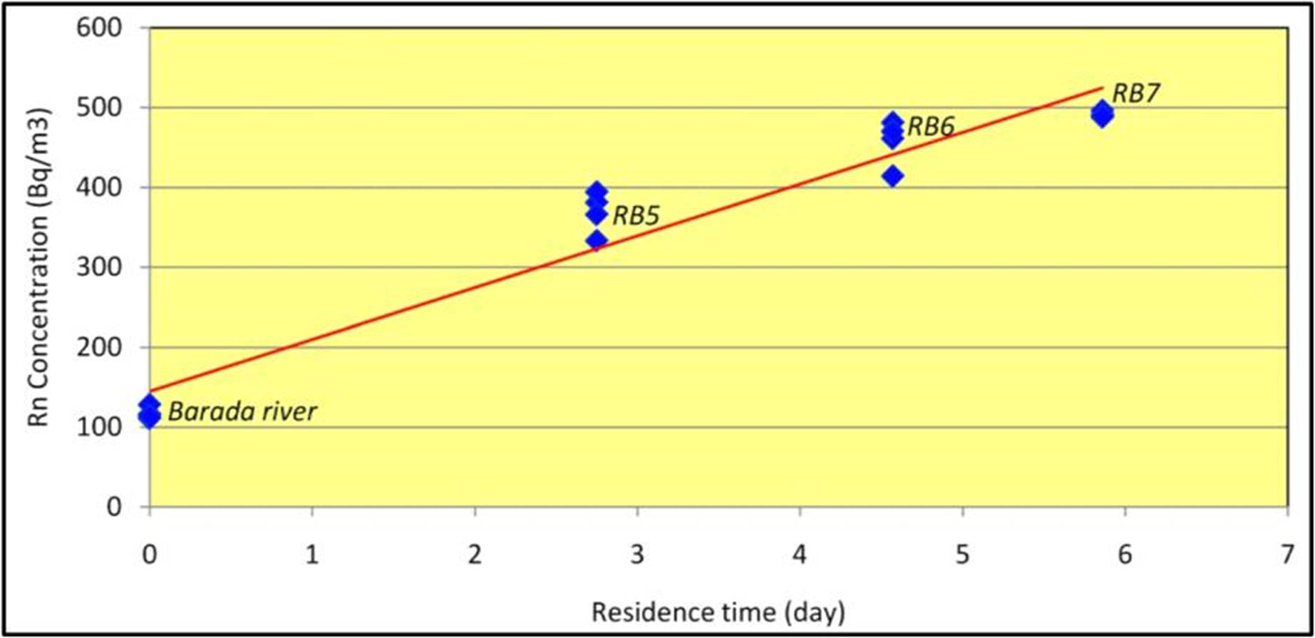
Figure 6 The relationship between radon concentration and the residence time of infiltrating river water, (RB indicates the observation wells).
As a matter of fact, the Barada River has been constantly suffering from gradual degradation of both water quality and quantity, due to the notable acceleration of human activities and economic development accompanied by remarkable drought periods during the last few decades. According to the ecological system of the Barada River, three different types of pollution can be distinguished as possible contaminated factors in the study area:
Urban pollution, which is basically produced by sewage water and sludge originating mostly from urban areas, which contaminates the river, groundwater and soil.
Agriculture pollution, which is mainly resulting from chemical and natural fertilizers, application of pesticides and direct irrigation with waste water,
Industrial pollution by chemical agents and waste water discharging from the many industries around Damascus city.
Results of some physical parameters (TDS, EC, pH and T) along with chemical analysis for some major ions in water samples collected from the Barada River and the neighboring aquifer are listed in table 2.
Table 2. Analytical results of radon and radium concentrations along with some physicochemical parameters and major ions measured in water samples from Figeh spring, the Barada River and three nearby observation wells.
Both electrical conductivity (EC) and total dissolved solids (TDS) are defined as water quality parameters, which are commonly used to describe the salinity level in water. An elevated TDS concentration commonly indicates the presence of inorganic salts and some organic matter in water, while the EC is the measure of water capacity to conduct electrical current, which in turn is related to the amount of salts and minerals in the water. The origins of the ions that generate both TDS and EC are essentially derived from natural sources, such as seawater, geological formations, but also human activities, i.e. domestic and industrial waste and agriculture. For health reasons, the standards of quality that govern the limits of TDS in water vary between 500 and 1000 mg/l, and less than 1500 µS/cm for EC (Rusydi, 2018). Although the relationship between the TDS and EC parameters is not always linear and so the ratio of TDS/EC cannot be defined simply, they are generally correlated and expressed by the following basic equation: TDS = k EC (at 25 ˚C). According to the data in table 2, the clear influence of salinity in the water samples can be observed through the enhanced values of most variables, including major ions in addition to the EC and TDS parameters. In other words, the average concentration of ions in water samples that were collected from the Barada River and the groundwater of the nearby observation wells showed increases of about 2-3 times higher than the corresponding values of the Figeh spring water, as a fresh reference sample. Furthermore, correlation between TDS and EC in the waters of the Barada River and the observation wells (RB5, RB6 and RB7) with regards to Figeh spring as reference water is illustrated in Fig. 7. The figure depicts the distribution of salinity contents relating to various water types in the study area, including the surface water of the Barada River; the water of Figeh spring and the deep groundwater of the observation wells. Considering the ratio of TDS/EC and based on the data obtained through this study, the k value was found 0.81 for surface water of the Barada River compared to 0.75 for the reference freshwater of Figeh spring. This result revealed that the k value increased along with the increase of ions concentration in the water and thereby it seems highly depends on water salinity and material contents (Rusydi, 2018).
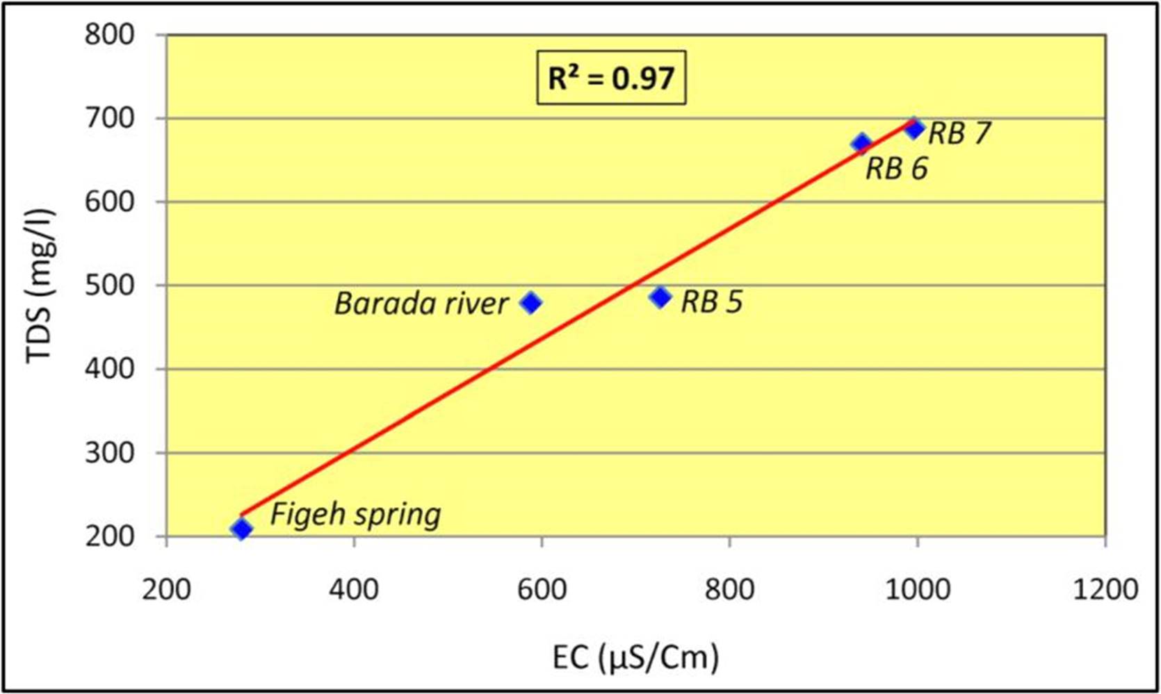
Figure 7 Correlation between EC and TDS in the waters of the Barada River, Figeh spring and the observation wells, (RB indicates the observation wells).
Moreover, the hydro-chemical composition of the Barada River water and the groundwater of the nearby Quaternary aquifer shows a solute content within the range of 479-688mg/l, with a notable progressive increase of total dissolved solids (TDS) from the river water towards the adjoining aquifer. On the other hand, radon concentration in groundwater showed some evidences of spatial increases trending in accordance with the salinity of the water. Furthermore, radon activity was found to be well correlated with EC values (R2 = 0.89), and to a lesser degree with TDS values (R2 = 0.67). Such correlation may be referred to the presence of some organic matter and small clay particles in the sediments of the aquifer matrix (Figs 8 & 9). However, the difference in the resultant values of (R2) due to the correlation of radon with both EC and TDS could be related to the nature of the measured karst water, which showed higher average concentrations of EC compared to the TDS values, as shown in Table 2.


The mineralization of the groundwater in the study area is primarily controlled by geological conditions, particularly the interaction of water with karstified carbonate rocks which make up the most prevailing lithology in the main aquifer systems. Hence, the general composition of the water in the region is basically of calcium-magnesium and bicarbonate type, with evident increase of some major ions such as Ca2+, Mg2+ and HCO3- (Table 2). These relatively high values mostly reflect the predominance of the dissolution of limestone and dolomite rocks in the recharge zones. Further, the content of nitrate (NO-3) in both the surface water and the sampled groundwater of the wells revealed values of 12.5, 7.4, 7.0 and 12.3 mg/l respectively. Although such nitrate values do not exceed the recommended level given for water domestic uses (~40 mg/l), they showed preliminary indications of groundwater contamination that is mostly related to sewage water and sludge produced from human activities. Additionally, the measured pH values of the water samples varied from 7.75 to 8.10. The relatively high pH values mostly indicate the outcome of water-rock interaction in such calcareous-rich geologic environment. Although the main source of the groundwater in the study area is almost the same aquifer, which is commonly composed of highly karstified limestone and dolomites of Cenomanian-Turonian age, some notable variations of pH values may possibly indicate probable anthropogenic pollution, due to mixing of groundwater with contaminated surface river water.
Based on field geological evidences, it can be observed that the karstified layers of the upper Cretaceous unit that are extensively outcropped on the flanks of Mount Qasioun and overlooking the study site at Rabwe, seem to be passing down underneath the Quaternary aquifer system. This means that the Barada River may play a major role as a source of groundwater recharge, especially for the nearby shallow fluvial-alluvium aquifer, as well the underlying karst aquifer system. Accordingly, this would allow an assumption that there is a possibility of direct hydraulic connection between both aquifer systems at depth. Hence, a probable interconnection may occur between the contaminated surface water of the Barada River and the underlying fresh groundwater aquifer. Such an assumption has unfavorable environmental implications, as this issue could be of high interest when evaluating the vulnerability of such aquifer systems to pollution. In view of that, a serious problem has been repeatedly raised in terms of pollution and balancing between the high demands of water due to high rate of population growth in the study area on the one hand and the limited freshwater resources on the other. Although fluvial-alluvial and karst aquifer systems are considered as important water resources worldwide, they are highly vulnerable to contamination, due to high permeability and the presence of preferential flow pathways along fissures and other conduits. Based on the above discussion, it can be concluded that hydrochemical measurements in addition to geological investigations and monitoring radon activities revealed primary indications of possible vertical and lateral infiltration from the Barada River to the neighboring aquifer. Consequently, groundwater aquifers that extend along the margin of the Barada riverbed seemed to be particularly vulnerable to a risk of environmental pollution, owing to recharge processes by infiltration of surface waters.
Eventually, the application of the radon technique as a natural tracer in hydrogeological studies may provide important information on the dynamics of groundwater recharge and thereby assist characterization of the aquifer structure, especially in shallow alluvial and karst systems. This is because of the intergranular spacing of unconsolidated particles or the openings in karst aquifer systems, which constitute preferential seepage paths for radon which is carried away dynamically by the circulation of groundwater. Thus, radon could fulfill the main requirements for being used as a natural environmental tracer, because of its ubiquitous occurrence in nature, its chemical and physical properties, and the simplicity of its detection. Yet, radon application in the field of hydrogeology is not without difficulties. Problems may arise due to heterogeneity in mineralogical composition of the aquifer sediments, which is mostly led to a non-homogeneous radium concentration in the soil matrix, and so radon might not be emanated uniformly throughout the investigated medium. Moreover, local changes in the lithological nature and physical properties of the subsurface sediments or rocks could result in substantial differences in permeability, which will be of high influence on the dynamics of flow characteristics. Therefore, when using radon as tracer to solve some important hydrogeological issues, it is essential to ensure that the measurement conditions of radon are properly met and the geological setting of the study site is accurately determined.
Conclusions
Using radon as a naturally occurring radiotracer to assess infiltration from the surface water of the Barada River to the groundwater of the nearby aquifer system at Rabwe site, revealed the following conclusions:
Within the accuracy of the applied technique and suitability of the investigated site, radon could be used as a fast and straightforward natural tracer to examine the interactions between surface and ground waters, especially in karstic and shallow fluvial-alluvial aquifer systems.
Taking into consideration the relatively short half-life of radon-222 (3.82 days) and based on the standard growth law of radioactivity, the residence time of bank-filtrated water from the Barada River to the adjacent aquifer was estimated for a time window of about 15 days (i.e. ~four half-lives of radon).
Evidence was found that the radon concentration in groundwater varied spatially, trending in accordance with the salinity of the water. Furthermore, radon activity was found to be fairly correlated with both EC and TDS content values, and this could be referred to the presence of some organic matter and clayey minerals in the sediments of the aquifer matrix.
As the geology of the study terrain is marked by extensive development of karst, so radon could provide valuable information on the characteristics of the aquifer structure and the dynamics of groundwater recharge, which can be of high interest when evaluating the vulnerability of such aquifer systems to environmental pollution.

