


 text new page (beta)
 English (pdf)
 Article in xml format
 Article references
 Send this article by e-mail
 Cited by SciELO
  Similars in
SciELO
Similars in
SciELO 
 Permalink
Introduction
A valuable record of neo-tectonic events over the last ten thousands years can be provided by the Quaternary and recent sediments, composed mainly of soft sediments with a cover of top soil. They highly very susceptible to the weathering and could be removed away in a little time. This might completely or partially efface the traces of surface expressions, recording and containing the recent tectonic events. Those important records could be also erased by increasing the levels of the human activities since the dawn of civilization that range from the land cultivation to the construction of giant dams. The main challenge in the active tectonic studies is the need to improve our knowledge about the morphotectonic mapping of active surface tectonic features with subsurface data to receive convincible and well-preserved 3D images of Quaternary structures.
Generally, the different geophysical techniques that we are using today have been designed to satisfy the increasing demand of society for new resources of mineral, water, and energy. Those different resources are usually localized at big depths. In the neo-tectonic research, in contrast, the scope is reversed. Several high-resolution seismic reflection surveys have been recently realized in the last few years to explain the geometry and timing of the Quaternary fault (Williams et al., 1995; Palmer et al., 1997; Van Arsdale et al., 1998). Ground-penetrating radar (GPR) has been applied in the San Francisco Bay region by Cai et al., (1996) for very shallow investigations. GPR technique bridges the gap between the high-resolution seismic investigations and the trenching. Although this GPR provides with a high-resolution image down to 4 m to 6 m, but the high number of GPR reflections and diffractions resulting from the sedimentological complexity and the tectonic features does not usually allow an unambiguous location of a fault (Demanet et al., 2001). However, subsequent interpretation of GPR measurements can provide us with valuable information on the deformation patterns close to the fault if it is delineated by using other geophysical techniques such the one described in this paper.
Shields et al., (1998) used different geophysical methods (magnetic, electromagnetic and seismic reflection methods) to delineate the fault zone extension of the Parhump Valley near the Nevada and California border. Demanet et al., (2001) practiced also various geophysical techniques (electrical profiling, electromagnetic, GPR, seismic reflection) along the Bree fault scarp (western border of the Roer Graben) to image and locate the active fault zone over a depth ranging from a few decimeters to a few tens of meters. The interpretations of those geophysical data were already used as a useful reconnaissance tool to smartly guide the direct investigations by trenching.
Several other examples of the use of multiple geophysical methods for investigating the shallow neo-tectonic features are provided by (Parrales et al., 2003, Caputo et al., 2003; Chwatel et al., 2005, Caputo et al.; 2007; Fazzito et al., 2009; Piscitelli et al., 2009). Massoud et al., (2009) recently used the directional azimuthal resistivity sounding and joint inversion of vertical electrical sounding and time electro-magnetic (VES-TEM) measurements to delineate the shallow subsurface structures near Lake Qaroun, El Fayoum, Egypt.
The water resources in Khanasser valley region in northern Syria have been successfully estimated by applying methodological researches, based mainly on the direct geoelectrical current (DC) methods, particularly VES soundings (Asfahani, 2007a and b, 2010). Those researches applied the enhanced Pichgin and Habibullaev technique (1985) to the acquired VES data to delineate the different subsurface structures and to outline fresh, brackish, and saline water accumulations. Asfahani and Radwan (2007) improved and update the efficiency of the Pichgin-Habibullaev technique to make it easily applicable in the pronounced topography areas. Accordingly, shallow and young subsurface structures were defined and characterized to be the essential basis for establishing the tectonic origin of Khanaser Valley as a graben, which developed during Pliocene-Quaternary and accompanied with cycled volcanisms.
Several geoelectrical techniques were recently applied by Asfahani et al., (2010) in Al -Lijj area, northwestern Syria to determine the subsurface tectonic structure of Kastoon dam in Al-Ghab depression. Al-Fares and Asfahani, (2018) applied also electrical resistivity tomography (ERT) and VES sounding techniques with different interpretative approaches to determine the subsurface tectonic conditions of Abu Baara dam in Northern Syria. Asfahani (2018) has proposed and developed a combined geoelectrical array having a good resolution in comparing with the traditional Schlumberger configuration for characterizing the shallow and deep structures. Asfahani and Al-Fares, (2021) proposed a new fractal technique to interpret the VES data along a given profile, and to explain the evolution scenarios of different basalt structures along the studied profile.
The above encouraging geoelectrical results motivate us to apply the geoelectrical techniques and the enhanced Pichgin and Habibullaev interpretation approach in the active tectonic domain in Al-Ghab pull apart, that has been developed at the northern segments of the Dead Sea fault System in Syria.
A shallow and deep penetrating Schlumberger configuration is accordingly designed to characterize structurally the shallow Quaternary and recent sediments, as well as the deeper structures located at depths of <250m in Al-Ghab depression region, where five profiles (Pr-1, Pr-2, Pr-3, Pr-4, and Pr-5) were studied and analyzed (Asfahani, 2010-a).
A suitable shallow-depth penetrating configuration in the order of less than 10 m is designed herein aiming at disclose the shallow-depth deformation and structures in Quaternary sediments, which are good indications of active and neo-tectonic events.
The reliability of this designed configuration and its efficacy in detecting deformations in Quaternary sediments is tested on a selected site in Mhambel area along the N-S Al-Ghab eastern faults.
The main objectives of this paper are therefore the followings:
Testing the validity and the merit of the shallow-depth penetrating VES configuration purposely-developed for detecting active tectonic deformation in the Recent and Quaternary sediments at a test area located on active faults.
Acquiring the geoelectric responses of different morphotectonic features in the Recent and Quaternary sediments mapped in the selected test area, through the employment of the adapted VES configuration with the proposed integrated geoelectrical approach.
Applying the acquired geoelectrical response on other areas to predict their neo-tectonic activity.
Geology and tectonic setting
Figure. 1 indicates the Syrian map, in which the study area of Al-Ghab and the main tectonic features in Syria are shown.

Geology (Stratigraphy)
Rock types outcropped at the eastern side of Al- Ghab pull apat and Rouj depression (Figure 2) consist of 150 m thick 5-7° eastward dipping Cenomanian-Turonian sequence composed of massive, moderately and thin- bedded limestone and dolomites with marl and limestones intercalations.

The sequence is overlain by 40-45 m thick Campanian marl and limestone and discordantly overlain by 180-225 m thick Middle Eocene (Pg2) limestone with white clayey chalk like limestone interbeds.
The overlying Tortonian (N 1 : Lower Miocene) sediments composed of 410 m basal conglomerate changes with sandstone interfingering, followed by a 150 m thick series of grey calcareous sandstone interbedded with siltstone, marl and conglomerate, ending with arenaceous marl with sandstone lenses and bands outcropped near Mhambel. The series, decreasing in thickness southward, is replaced by coarse pebble and boulder conglomerate indicating its closeness to the Tortonian sea coastline.
Large Pliocene basaltic rocks (βN 2 ), extruded from eight highly eroded, oval shaped volcanic cones (1km×100m), cover the northern end of Al-Ghab pull apart and the sourthern parts of the Rouj depression with a maximum thickness of 60m. They are composed of dolerite, anamesite, hyalobasalt and teschenite, nepheline basanite, analcite anamesites, alternated lavas, tuffs and slags. Their surface is slightly inclined southward and buried under Upper Quaternary and Recent sediments. Lower-Middle Quaternary (Q 1 ) is represented in northeastern Al-Ghab by shell limestone and Proluvial poorly sorted conglomerates and pebble beds is encountered. Upper Quaternary (Q 3 ) alluvium is composed of flinty pebbles and brown loams, while the proluvium and the deluvium is composed of clays, loams, sandstone with clay fragments and gravels mixtures. Lacustrine sediments form a low terrace-like platform, 0.5-3 m high composed of yellow silty sands and dark brown nearly black loam 1m.
The lacustrine, deluvial and proluvial sediments bear flint implements, ceramics and polished basaltic items considered as old as 6000-8000 years. The Recent (Q 4 ) sediments are alluvial pebbles beds, loam and Orontes River sandy loam. Recent lacustrine sandy clay passing upwards into black peaty loams (3-4 m thick) fill the centre of Al-Ghab depression, (Ponikarov, 1966).
Tectonic
From the tectonic point of view, the research test areas are located at the western rims of Al Zawiyeh Mountain, bounded by Al- Ghab eastern faults, which are segments of the N-S Dead Sea Fault System (DSFS) extension in Syria. Two structures were developed along Al-Ghab Eastern faults; the Al-Ghab pull apart and the Rouj depression. Brew et al., (2001a, 2001b) consider the 15×25 km N- S elongated Al-Ghab pull apart, as a deep structure opened in response to a left-step in the DSFS during Pliocene to Holocene. The northern tips of Al-Ghab eastern faults deviates at Qlaidin village from their N-S regional strike marking the initiation of the wedge-shaped Rouj depression elongated in the NNE (Figure 2). Many workers such as Quennell, 1984; Beydoun, 1999 believe that the Dead Sea fault system is an active major sinistral transform plate boundary between the sinistraly northward moving Arabian plate relative to the African Plate (Levantine subplate) developing complex deformational structures oriented according to the stress field prevailed along it, e.g. Dead Sea, Tiberias lake, Bekaa Valley and Al-Ghab Depression. A double-episode lateral movement was suggested by Quennell (1959) along the DSFS, expressed by a Miocene 60 to 65 km slip on the system's southern segment (Freund et al., 1970; Quennell, 1984), and Post-Miocene 20 to 25 km sinistral motion on the system's both southern and northern segments. The second phase was accompanied by additional 20 km suggested to be accommodated by shortening of the adjacent Palmyride fold and thrust belt (Chaimov et al., 1990), making the total post-Miocene slip amounts 40-45, and 105 km on the northern system and southern segments respectively.
The geomorphological evidences for Pliocene -Recent tectonic activity (Hricko, 1988; Darkal et al., 1990; Radwan et al., 1994a, 1994b; Devyatkin et al., 1997), the seismic evidences of Ambraseys and Jackson (1998) , paleoseismic evidences of Serghaya fault and Al -Ghab pull apart, (Meghraoui et al., 2003; Gomez et al., 2001, 2003); and GPS measurements (McClusky and Balassanian, 2000; Gomez et al., 2006), collectively gave additional support to the system current activity, denying Butler et al., (1997) , argument that the northern segments of the DSFS have been inactive since Miocene.
Geomorphotectonic features at Mhambel calibration site
The calibration test site lies 1.3 km at the south of the village of Mhembel at the N-NE faulting zone, which deviates from the N-S regional trend of the northern segments of the DSFS, and bounds the eastern edges of the Rouj valley (Figure 2).
The rocks, at the area of Mhambel village, are mainly Middle Eocene (Pg2) limestone interbeded by thin beds of clayey and chalky limestone and overlain by Tortonian sandstone, calcareous sandstone, siltstone, marl and arenaceous marl lenses. These rocks outcrop at both sides of the valley of Sakhreen transient stream, which crosses through Mhambel village. The mapped Pliocene basaltic rocks (βN 2 ) in Sakhreen valley and south of Mhambel were extruded from a heavily eroded volcanic cone located in the mentioned valley. Most of Mhambel village is built from materials composed of loam, clay, sandstone and gravels mixtures that are incised by the current running water of Sakhreen stream. Deluvial and proluvial sediments of varied thickness cover sporadically the slopes south of the village.
An excavation at 1.3 km south of Mhambel, disclosed a N-NE normal fault cuts through the fan sediment and the underlying Tortonian rose sandstone (Figure 3).

This site was selected as an ideal fault exposure for calibrating the adapted shallow VES geolectrical configuration developed with its small AB/2 spacings not exceeding 50 m to detect and trace the active faulting due to the followings:
1. The presence of a clear cut vertical displacement of an active normal fault,
2. The limitation of the fault exposure area,
3. The striking lithological difference between the soft Tortonian marly sandstone and the rough Recent fan gravel sediments,
4.The negligible effects of weathering processes on the active faulting zone. Accordingly, the break in the moderate slope upon it, the developed colluvial wedge and fault scarp were well preserved,
5.The youngness of this representative active faulting, makes the use of this developed VES configuration applicable and promising in detecting blind active faults elsewhere.
Material
Vertical electrical sounding (VES) Technique
The apparent resistivity measurements were carried out using the Indian resistivity meter model ACR-1. Eight vertical electrical sounding were carried in the location study area. The traditional Schlumberger configuration is adapted and used to acquire the apparent resistivity data by means of vertical electrical sounding (VES), with a half maximum current electrode spacing (AB/2) of 48.87 m and potential electrode spacing (MN/2) of 3 m.
The specific AB/2 spacings used in this designed adapted VES array are 1, 1.3, 1.68, 2.18, 2.82, 3.66, 4.74, 6.15, 7.97, 10.33, 13.38, 17.35, 22.49, 29.15, 37.78 and 48.87 meter. The Resistance (R a ) was first recorded in the field, and converted later to apparent resistivity (ρ a ) for the Schlumberger array by the use of the following equation:
This equation was reduced to: ρ a= GRa
where G is the geometric factor.
The field apparent resistivity curves were obtained by increasing the electrode spacing AB/2 about a fixed point. Those vertical electrical sounding curves were thereafter plotted in the next stage for each of the survey locations, and smoothened to remove noisy signatures (Chakravarthi et al., 2007; Ebong et al., 2006). We use the curve matching technique with master curves for interpreting the field resistivity curves to determine an initial model including resistivities and thicknesses of the corresponding layers (initial approximate model) (Orellana and Mooney, 1966). The inversion WINRESIST software program is thereafter used to interpret the parameters of the approximate model to get the final optimum model, in which a goodness of fit between the field resistivity curve and the final theoretical regenerated curve was arrived (Zohdy, 1989; Zohdy and Bisdorf, 1989). This inversion procedure allows estimating the values of the true resistivity, depth and thickness of the subsurface after several iterations for each VES point.
Pichgin and Habibulaeve Technique
Pichgin and Habibulaeve (1985) have already developed a geoelectrical technique aimed at interpreting vertical electrical sounding (VES) points, measured and distributed along a given profile. This technique is considered as one of the best technical methods established for distinguishing tectonic fractured zones and dipping contacts. This 2D interpretative technique allows also the determination of the direction and inclination of faults under a given geoelectrical profile, hence a 2D subsurface tectonic image can be derived.
The basic of this technique can be described as follows: When an electrical current passes through a contact of two outcropping formations of different resistivities ρ1 and ρ2, the injected electrical current boundary conditions at this contact will be explained according to Pichgin-Habibullaev technique as follows:
1. If the direction of the symmetrical electrode Schlumberger configuration of the four electrodes is perpendicular to this contact, and if the center point of the VES sounding is located just over a vertical contact between two formations of different resistivities ρ1 and ρ2, the apparent measured resistivity ρK is expressed in this case by the following equation:
The measured VES resistivity is independent from AB and MN lengths.
If there are two vertical electrical soundings VES1, VES2, measured on both sides of a vertical contact (Figure 4), in such a case, all the geoelectrical profiling curves presented as a function of distance between the different VES points, for all the used AB/2 will be intersected in only one point, located directly over this vertical contact (Figure 4). Every geoelectrical profiling clearly shows the apparent resistivity variations for a given AB/2 (Figure 4).The vertical electrical soundings data for all the VES points distributed along a given profile are therefore transferred to be represented as horizontal multi-depths profiling curves for every givenAB/2. The locations of vertical electrical soundings, realized on such a given profile are plotted on abscissa using a linear scale, while the corresponding apparent resistivities (ρk or ρ‘k) for each given AB/2 are plotted on the ordinate using a logarithmic scale. This resistivity is also independent from AB and MN lengths.

2. If the direction of the symmetrical electrode Schlumberger configuration of the four electrodes is parallel to such a contact, the apparent measured resistivity ρ`K is expressed by the following equation:
The intersection points of the horizontal geoelectrical curves represented for the different AB/2 are called the non-homogeneity points (PNH) symbolized as (+). Those PNH are plotted on a 2D (x, y) geological section. The depth (z) of each PNH is determined from to the following equation:
Where (AB/2) i and (AB/2)j are the half-spacings between the electrodes A and B, at which two horizontal curves are intersected.
A computer program developed by Asfahani and Radwan (2007) is used to determine the positions and locations of the PNH . Geological interpretations of the PNH could be achieved according to the Pichgin-Habibullaev technique, based on the following assumptions:
1. The presence of an inhomogeneous lithologic contact is decided when the PNH are distributed along oblique lines located at shallow depths.
2. A fractured zone is decided if PNH are arranged along oblique lines dipping at an angle exceeding 30° at depth.
3. An homogeneous lithology is decided if PNH are scattered randomly near the surface.
4. Certain geological structures, such as synclines, anticlines, or horizontally layered strata could be decided if PNH are arranged in regular forms.
The above four assumptions have been calibrated and verified through different field tests, particularly in Syria, including different lithologies and structural architecture (Asfahani and Mohamad, 2002; Asfahani, 2007a,b; Asfahani and Radwan, 2007; Asfahani et al., 2010).
However, it is to mention that the basic original Pichgin and Habibullaev method, being developed only for smooth topography gives inaccurate and sometimes misleading tectonic interpretations in areas of rough topography (Pichgin and Habibuleav, 1985). Asfahani and Radwan, 2007 therefore modified and enhanced slightly this technique to attain a reliable subsurface tectonic interpretation, by taking into consideration the real absolute elevation of each measured VES point. Numerical values of the topography elevations of the VES points were incorporated in the processing software through purposely-developed mathematical formulas as additional crucial factors to achieve enhanced Pichgin and Habibuleav profiles.
The mentioned development and enhancement was performed according to the four following successive steps (Asfahani and Radwan,2007):
1. Constructing a real topographic profile passing through VES station positions of a given VES profile, hence real absolute elevation of the VES station is considered.
2. For every pair of successive resistivity VESs, of AB/2 spacing along a given profile, all intersections points are localized and projected on a real topographic profile constructed in step-1. In the original Pichgin and Habibullaev technique, all the intersection points are projected onto a zero reference level, assuming that all VES stations have the same elevation.
3. The intersection points, together with the topographic profile constructed in step-2, are projected onto the X-Z plane, to obtain (PNH), whose depths Z are similarly determined by using equation (5).
The location of (PNH) depths by using the enhanced method is more sophisticated and reliable in extrapolating the sub-surface structures, where real and true elevation of the inter-section PNH points is determined with reasonable accuracy.
Procedures of step-2 are repeated for all AB/2 spacings, to localize all possible (PNH) in the X-Z plane.
A computer program was already developed to enable the performance of the aforesaid 4-steps enhancement through processing the VES resistivity input data, hence acquiring enhanced Pichgin and Habibuleav VES profiles, that could be interpreted according to the rules and conception previously discussed (Asfahani and Radwan, 2007). Thus the enhanced method became easily applicable in areas of hard topography and prominent relief, attaining real computer-aided topographic cross sections along VES profiles.
Asfahani and Mohammed, 2002 applied efficacy this technique for sulfur prospecting in North East of Syria. Asfahani and Radwan (2007), used this geoelectrical interpretative technique for solving different hydrogeological problems at Khanasser valley region, Northern Syria. Asfahani et al., 2010 interpreted the geoelectrical VES data by using this technique for determining the subsurface tectonics and their impacts on the Qastoon Dam, Northwestern Syria. Asfahani, 2010-a used it for solving subsurface structural and mining phosphate problems in Al-Ghab area and Al-Sharquieh mine in Syria respectively. This enhanced Pichgin and Habibuleav technique has been widely applied in different research published works, and proven its efficacy and importance in several geological applications (Asfahani, 2011).
Al-Fares (2016) conducted a geoelectrical VES survey, in which he used Pichgin and Habibuleav pseudo-2D method to maximize the reliability of the VES data interpretation. The results indicated the presence of a local faulted anticline structure at the top of the Paleogene formation, underneath the basaltic outcrops where Deir El-Adas village is situated, Southern Syria. Al- Fares explained in his paper that appearance of this subsurface anticline structure has considerably complicated the local hydrogeological situation, and most likely led to the limitation of the groundwater recharge in the Deir El-Adas area. Al- Fares and Asfahani, 2018 used also this technique through an integrated geophysical approach in the dam domain to identify the potential leakage zones within the substructure bedrock close to the Abu Baara earth fill dam, located at the southern margins of Al- Ghab plain northwest of Syria.
Sirwa and Asfahani, 2019 applied enhanced Pichgen and Habibullaev (1985) method, and proven its clear important role in providing subsurface structures, and in detecting the exact position, dip and direction of faults and groundwater level at Erbil Dumpsite, West of Erbil City - Iraqi Kurdistan Region.
Previous research works
Geoelectrical methods were already applied in the Al-Ghab depression region to characterize the Recent and Quater-nary structures. A slight modification on the Schlumberger configuration concerning the design of its spacings of AB/2 was adapted to get reliable image on the shallow penetration depths (<50 m), (Asfahani, 2011). The application of the adapted configuration with the proposed interpretative geoelectrical approach on studying and analyzing five profiles shown in Figure 2 (Pr-1, Pr-2, Pr-3, Pr-4, and Pr-5) allowed to get the real resistivities and thicknesses of the mentioned shallow structures as shown in Table 1.
| Recent | Quaternary | |||
|---|---|---|---|---|
| Profile # | Average ρ (Ω.m) | Average thickness (m) | Average ρ (Ω.m) | Average thickness (m) |
| Pr-1 | 44 | 1.6 | 12 | 29 |
| Pr-2 | 34 | 1.2 | 25 | 10 |
| Pr-3 | 25 | 6 | 20 | 17 |
| Pr-4 | 40 | 3.5 | 18 | 27 |
| Pr-5 | 22 | 2 | 34 | 9 |
Table 1 indicates that all the eight measured VES are interpreted by a model of three layers with a type curve.
| VES points | Resistivity (Ω.m) | Thickness (m) | RMS (%) | Curve type | ||||
|---|---|---|---|---|---|---|---|---|
| ρ1 | ρ2 | ρ3 | h1 | h2 | h3 | |||
| V1 | 64 | 131 | 19 | 0.3 | 1.5 | -- | 4.6 | K |
| V2 | 87 | 323 | 67 | 0.3 | 1.7 | -- | 3.7 | K |
| V3 | 49 | 385 | 74 | 0.5 | 1.8 | -- | 4.1 | K |
| V4 | 65 | 493 | 80 | 0.4 | 1.9 | -- | 5.0 | K |
| V5 | 98 | 634 | 104 | 0.3 | 2.2 | -- | 3.8 | K |
| V6 | 221 | 459 | 55 | 0.1 | 2.3 | -- | 5.1 | K |
| V7 | 115 | 501 | 66 | 0.2 | 2.6 | -- | 4.5 | K |
| V8 | 103 | 517 | 111 | 0.3 | 2.4 | -- | 5.8 | K |
The application of the enhanced Pichgin and Habibulaeve technique on the geoelectrical VES data distributed along those five profiles provided us with the shallow structures of the Recent and Quaternary deposits as shown in Figure 5.
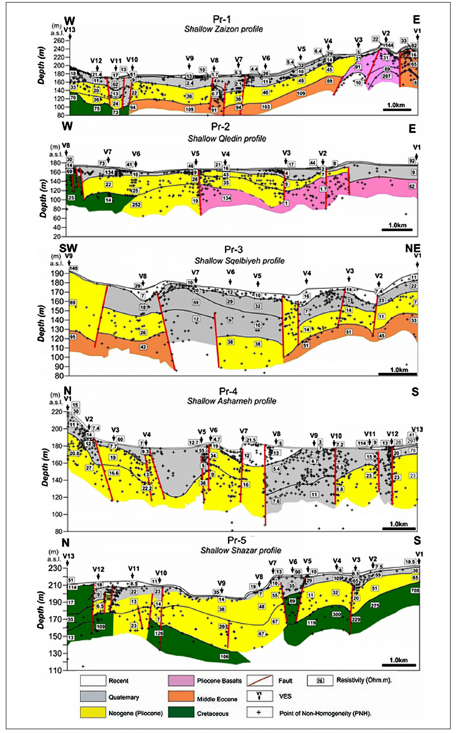
Figure 5 Recent and Quaternary structures obtained along Pr-1, Pr-2, Pr-3, Pr-4, and Pr-5 profiles (Asfahani, J., 2010a).
The results obtained on those mentioned profiles provoke us to update again the Schlumberger configuration to get geoelectrical information about only the shallower depths of less than 10 m.
Results and Discussion
The adapted shallow VES configuration with the interpretative geoelectrical approach is applied in this research to calibrate and test its applicability and efficacy to be used for detecting the Recent and Quaternary structures, considered as good records for the active tectonic features. It is applied in this paper on the surface perpendicular to the fault plane exposure shown in Figure 3.
Figure (6) shows the eight field VES curves with the variations of the apparent resistivity as a function of the half current electrode spacing (AB/2), that were carried out along a profile of 45m long over the faulted slope shown in Figure 3. The log-log scale is used, where the X coordinate represent the half spacing AB/2, while the Y coordinate represent the field apparent resistivity.

Those eight field curves have similar shape and reflect a special lithological structure near to surface that will be more identified with the following qualitative and quantitative interpretations.
The 1D quantitative interpretations of those VES soundings by the use of WINRESIST software of Velpen (2004) allows after several iterations to obtain the real model values of the true resistivity, depth and thickness of the subsurface layers for each VES point as shown in Figure 7 and 8, and Table 2. A model of three layers of K type of ρ1<ρ2>ρ3 is adapted for those interpreted eight VES.

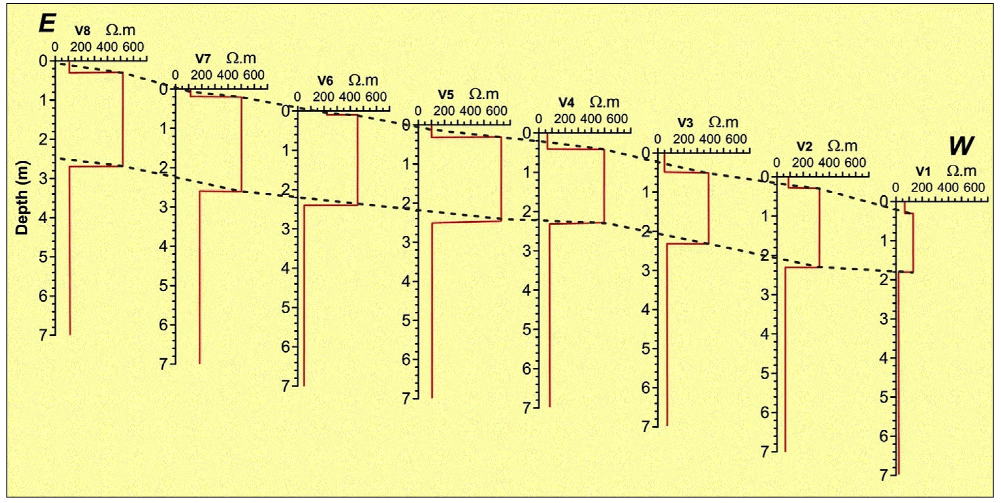
Figure 8 Two dimensional (2D) inversion resistivity-depth (R-D) model obtained by eight VES in the study Mhembel area.
The thicknesses of the first top soil layer varies between a minimum of 0.1m at V6 location and 0.5 m at V3 location. The resistivity of this layer varies between a minimum of 49 Ω.m at V3 and 221 Ω.m at V6.
The thickness of the second layer varies between a minimum of 1.5 m at V1 location and 2.6 m at V7 location. The resistivity of this layer varies between a minimum of 131 Ω.m at V1 and 634 Ω.m at V5. The resistivity of the third layer varies between a minimum of 19 Ω.m at V1 and 111 Ω.m at V8.
Figure 9 shows the 2D pseudo-section variations of the measured apparent resistivity as a function of AB/2 along the studied E-W profile.
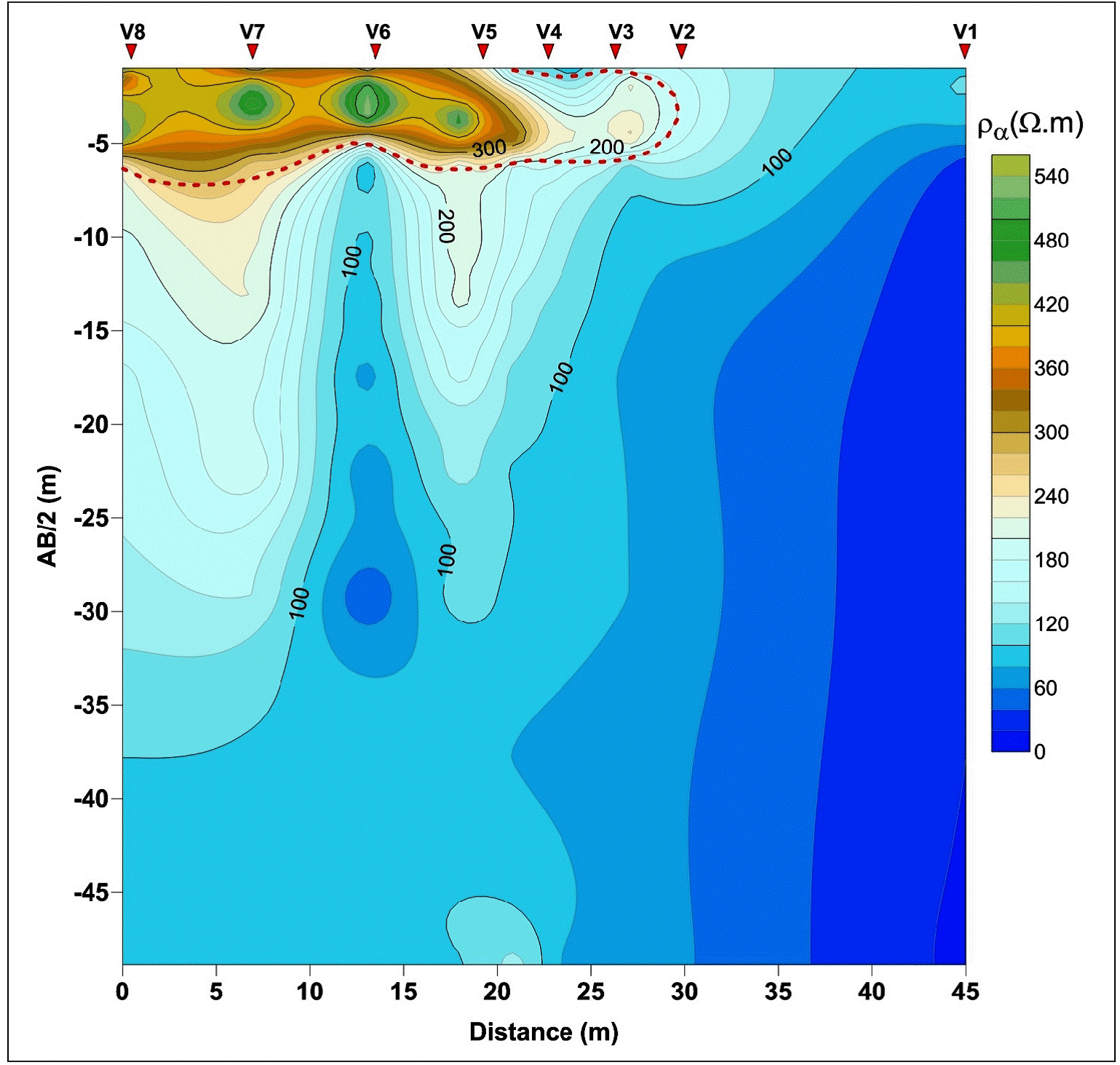
Figure 9 The pseudo section of apparent resistivity as a function of AB/2 (ρa= f (AB/2) along the study Mhembel profile. The Recent and Quaternary structure is well identified near to the surface.
This 2D qualitative interpretation proves that the adapted VES configuration with the proposed geoelectrical approach is highly sensitive to the surfacial layers structure located above 10 m, where its resolution diminishes considerably under 10 m depth.
The enhanced Pichgin and Habibuleav technique described above is used to interpret the eight measured VES soundings. The non homogeneity points (+) are obtained under the studied profile as shown in Figure 10.
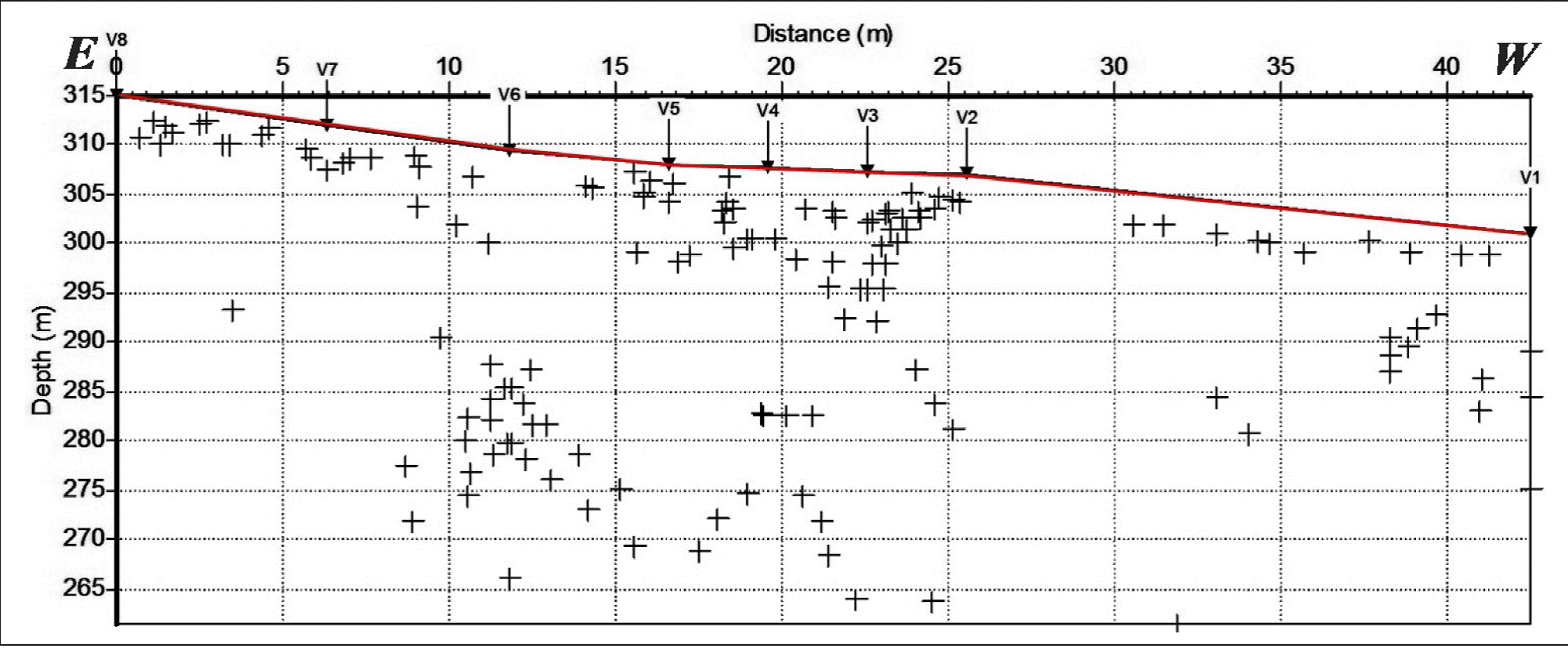
Figure 10 Non homogeneity points (+) obtained along the studied profile. The combination of the one dimensional (1D) results obtained by the quantitative interpretation of the eight VES soundings with the distribution of the non homegenity points allows to get the litho-struc-tural two dimensional model (2D) along the studied E-W profile as shown in Figure 11.
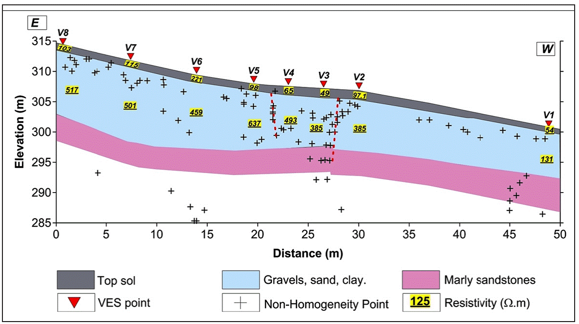
Figure 11 Two dimensional (2D) litho-structural model obtained along the E-W studied profile at Mhambel site.
The combination of the one dimensional (1D) results obtained by the quantitative interpretation of the eight VES soundings with the distribution of the non homegenity points allows to get the litho -structural two dimensional model (2D) along the studied E-W profile as shown in Figure 11.
The 2D constructed model shows essentially well the resistivity variations of the distinguished top soil layer and the second one. A faulted zone is detected and located between V2 and V5, where the non homogeneity points and their distribution with depth are located within this zone.
The projection of the same results shown in Figure 11 on a same scale field photo is done as presented on Figure 12 (a,b, and c), to test and calibrate the proposed geoelectrical configuration and to decide at which degree this configuration is apt for detecting shallow subsurface tectonic. This projection shows the details of the fault exposure under the slope and shows also a sharp resistivity layering correspondent to lithological differentiations between the Recent alluvial deposits and Pliocene light red marl and clayey marl extends from V1 to V2 Soundings. The non homogeneity points obtained by the enhanced Pichgin and Habibuleav profile are well located in the contacted and faulted zone, and reflect clearly the faulting and the resistivity changes related to the lithology of Tortonian and Quaternary.
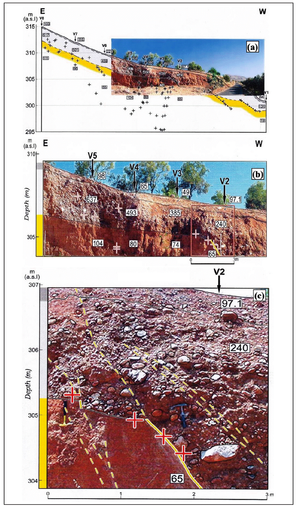
Figure 12 a): Real dimensional (2D) litho-structural model obtained along the E-W studied profile at Mhambel site; b): Detailed 2D model between V5 and V2; c): Detailed 2D model under V2.
The AB/2 spacing values ranging from 1 to 3.66 m could detect the shallow faulting, whose depth and width are less than 3 and 5 m respectively.
The AB/2 spacing values that range from 4.74 to 22.49 cannot detect those shallow faulting, nevertheless trace of deeper faulting which has no surface expression since it is covered by the Quaternary sediments. The observation indicates that the surface faulting is younger than the Quaternary sediments, while the deep faulting is older than it.
Conclusions
The application of the adapted VES configuration with the new geoelectrical approach proved that the electrical method is applicable and productive in detecting shallow depth tectonic deformation in Recent and Quaternary sediments, hence in active tectonic researches.
An electric signature of a normal faulting in a media of different lithologies is attained. The advantage of integrating this electric Schlumberger configuration within a geoelectrical interpretative approach is evident through its simplicity and rapidity. The integrated use of the measured VES data with the advanced and enhanced Pichigin and Habibulaieve interpretation approach makes the application of such an adapted array possible in a reliefed terrain, where a reliable image of the shallow subsurface structures can be reflected. The electrical signature obtained from the calibration of this adapted Schlumberger configuration at the selected site of Mhembel will guide electrical surveys performed in the frame of future active tectonic research to detect the subsurface buried normal faulting. The established subsurface geoelectrical imaging obtained by this geoelectrical integrated approach along different profiles in a given study area will in addition allow to determine later the privileged locations for trenching, used for studying the new active tectonic features.

