


Servicios Personalizados
Revista
Articulo
 texto en
  Inglés (pdf)
 Artículo en XML
 Referencias del artículo
 Enviar artículo por email
Indicadores
-
 Citado por SciELO
 -
 Accesos
Links relacionados
-
 Similares en
SciELO
Similares en
SciELO
Compartir

 Permalink
Tecnología y ciencias del agua
versión On-line ISSN 2007-2422
Tecnol. cienc. agua vol.11 no.5 Jiutepec sep./oct. 2020 Epub 10-Jun-2024
https://doi.org/10.24850/j-tyca-2020-05-10
Notes
Analysis of the interaction of surface water and groundwater in an Andean volcanic catchment, Chile
1
 http://orcid.org/0000-0001-7447-7790
2
http://orcid.org/0000-0003-0438-3080
1Universidad de Concepción, Concepción, Chile, vmparra@ing.ucsc.cl
2Universidad Católica de la Santísima Concepción, Concepción, Chile, emunozo@ucsc.cl
3Universidad de Concepción, Concepción, Chile, jarumi@udec.cl
4Universidad de Concepción, Concepción, Chile, jparede@udec.cl
In the south-central zone of Chile, the Renegado River presents irregular behavior during the dry season, with dry and high-flow sections along its course at the same time. The objective of this study was to identify interactions between surface and groundwater that explain this behavior. Through a flow measurement campaign along the river, an analysis of the geological conditions of the watershed and the use of a numerical groundwater flow model, the interactions between the water table and the river were described and represented. As a result, it was identified that the combination of topography and geology given by the volcanic nature of the catchment leads the river to gain or lose surface water along its course. It is recommended that the interaction between surface and groundwater be analyzed to address hydrological design studies and water management in volcanic systems with similar characteristics.
Keywords: Surface water and groundwater interaction; geology; mountain hydrology
En la zona centro-sur de Chile, el río Renegado, durante la época de estiaje presenta un comportamiento irregular, con tramos secos y de alto caudal, intercalados a lo largo del río al mismo tiempo. Este estudio tiene por objetivo identificar interacciones entre aguas superficiales y subterráneas que permitan explicar dicho comportamiento. Mediante una campaña de medición de caudal a lo largo del río, un análisis de las condiciones geológicas de la cuenca y el uso de un modelo numérico de flujo de agua subterránea, se describen y representan las interacciones entre el nivel freático y el río. Como resultado, se identifica que la combinación particular de topografía y geología dada por la naturaleza volcánica de la cuenca lleva al río a ganar y perder aguas superficiales a lo largo de éste. Se recomienda analizar la interacción de agua superficial y subterránea para abordar estudios de diseño hidrológico y la gestión del agua en sistemas volcánicos con características similares.
Palabras clave: interacción de aguas superficiales y subterráneas; geología; hidrología de montaña
Introduction
Understanding interactions between surface water and groundwater is important for effective water resources management. These interactions along rivers are controlled by watershed characteristics such as topography and geology (Banks et al., 2009). Topography is crucial in the control of interactions between groundwater and surface water (Harvey & Bencala, 1993), especially in areas with a steep relief.
The interaction between surface water and groundwater and its relationship with topography and geology has been studied by various researchers (e.g., Harvey & Bencala, 1993; Fan, Toran, & Schlische, 2007; Banks et al., 2009); however, very few studies have been carried out in fractured rock aquifer systems (Banks et al., 2009). Normally, fractured systems are influenced by volcanic processes that are substantially more complex due to the geological heterogeneity of fractured rock aquifers. Some mountainous areas are highly influenced by volcanic processes, including the Upper Diguillín River watershed in Chile (Dixon et al., 1999; Naranjo, Gilbert, & Sparks, 2008) and the area influenced by El Chichón Volcano in México (Peiffer et al., 2011). Volcanic deposits are normally composed of fractured and permeable formations that promote interactions between surface and groundwater (Arumí, Rivera, Muñoz, & Billib, 2012). These interactions are known as “water losses” and “water gains” and can invalidate the “hydrological similarity” assumption (Reed et al., 2006; Wagener, Sivapalan, Troch, & Woods, 2007) commonly used for streamflow estimates and hydrological design. The "hydrological similarity" assumption is based on watersheds with similar characteristics (e.g., geomorphology, climate and land use) behaving similarly with respect to runoff generation. However, this assumption may not be met as a result of certain topographical and geological characteristics of the watershed and may not be valid even at local (sub-watershed) scale.
Previous studies have shown the existence of significant interactions between surface water and groundwater in south-central Chile. For example, Zúñiga, Muñoz and Arumí (2012) estimated that 75% of the low-water baseflow of the Renegado River infiltrates and is subsequently transferred underground to the Diguillín River watershed. Arumí, Oyarzún, Muñoz, Rivera and Aguirre (2014a) identified a series of springs in the Diguillín River that contribute approximately 4.5 m3/s from a fractured rock system that is recharged by rainwater seepage in the Renegado River valley. Recently, Muñoz, Arumí, Wagener, Oyarzún and Parra (2016) complemented prior studies. The authors studied the complexity of hydrological processes in volcanic mountain watersheds and mentioned that additional efforts are needed to understand the main processes in these systems.
Thus, this work aims to deepen the analysis of the local interaction between surface and groundwater in the Renegado River and allow an understanding of the river water infiltration processes in order to propose recommendations for hydrological analysis and design in mountain watersheds with fractured rock geological systems. The analysis of the interactions was carried out through 1) a streamflow measurement campaign in a stretch of the river (in the low-water period), and 2) a groundwater model developed in Groundwater Vistas (MODFLOW).
Study area
The Renegado River watershed is a volcanic watershed located in the Andes of south-central Chile (Figure 1 (a)). The watershed (127 km2) is monitored by the Renegado at Invernada streamflow gauging station. It is covered mainly by native forest and is composed of highly permeable soil layers (Arumí et al., 2014a). The elevation map (Figure 1(b)) shows that its altitude varies between 584 and 3 180 masl. The area presents a predominantly pluvial regime with mean annual precipitation of around 2 371 mm (Muñoz et al., 2016); however, 5% of years exhibit a snowmelt-related influence (Rubio-Álvarez & McPhee, 2010).
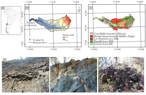
Figure 1 (a) Location of the study area in Chile. Additionally, (b) topographic map; (c) geological map; (d) Los Pincheira lava formation; (e) Diguillín lava formation and (f) Atacalco lava formation are shown.
Dixon et al. (1999) and Naranjo et al. (2008) describe that the area was formed by a series of volcanic processes associated with the Nevados de Chillán volcanic complex. This system is composed of various types of lava (Figure 1(c)), formed through different processes that have taken place in the last 650 000 years. These lavas present high permeability due to the high grade of fracturing in the rocks as a result of their rapid cooling upon contact with the environment.
In particular, the Renegado River watershed presents three predominant geological formations (Naranjo et al., 2008): 1) Los Pincheira lavas, which were deposited in the Middle Pleistocene, completely filling the valley during a glacial period. One of their most important characteristics is deep jointing due to contact with the glacier, which promotes rapid groundwater movement (Figure 1(d)); 2) Diguillín lavas, also formed during the Middle Pleistocene, which extend along the Renegado River valley. Because they were blocked by the Los Pincheira lavas, their path deviated, forming the connection with the Diguillín River (Figure 1(e)); 3) Atacalco Lavas, which were deposited in the Middle Pleistocene and, like the aforementioned lavas, filled the Renegado River valley, laterally covering the Los Pincheira and Diguillín lavas. Along the Renegado valley it is possible to observe mostly Atacalco formations of the type shown in Figure 1(f).
Methods
To analyze the interactions between surface water and groundwater in the Renegado River two approaches were used. The first approach was based on a streamflow gauging campaign and the second on the development of a groundwater model in Groundwater Vistas (MODFLOW) to represent and analyze the interactions and better understand the relationship between the water table and the topography and geology in the study area.
Gauging campaign
The gauging campaign was carried out in the low-water (low-streamflow) period and covered a ~12.2-km stretch of the Renegado River. As the upper and lower stretches of the Renegado River are located in a hard-to-access area, the campaign was limited to the middle segment of the river (Figure 2), an area in which interactions between surface water and groundwater have been observed in previous campaigns.
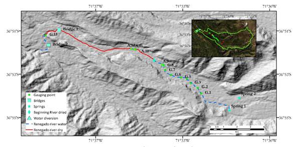
Figure 2 Gauging locations along a 12.2-km stretch of the Renegado River. In addition, the locations of the boundary conditions (springs) used in the groundwater model, the dry stretch of the Renegado River (solid red line) and the river stretch with surface water (dashed blue line) are shown.
Thirteen gaugings were carried out in January 2015 (see points in Figure 2). For the measurements the methodology used by the General Water Directorate were used (DGA, 1991). The instrument used was a Valeport model 801 electromagnetic flow meter.
During the fieldwork the following situations in the river were observed: i) An artificial water diversion (see location in Figure 2) that has a significant effect on the river streamflow was found; ii) the river dries up completely in two stretches (see solid red lines in Figure 2); iii) a significant undocumented spring was found (see point in Figure 2).
Eight gaugings were carried out between the first measuring point to the water intake. Gauging 9 was carried out downstream of point 8 (~100 m). In the dry stretch of the river (~ 500 m downstream of point 9) 3 smaller gaugings associated with 2 small springs were carried out (gaugings 10 and 11). Finally, gauging 13 (see location in Figure 2) was carried out downstream of Bridge 1 (first square in Figure 2).
Additionally, in order to analyze the hydrological similarity assumption and the ensuing assumption of streamflow proportionality with tributary area, it was estimated how streamflow would increase downstream of each gauged point. To this end, the tributary watersheds of each measured point were delimited and the streamflows at each point were calculated assuming a linear, directly proportional relationship between streamflow and tributary area. The obtained results were then compared with the streamflows measured in the gaugings.
Groundwater model
A groundwater model was implemented in Groundwater Vistas (version 6), developed by Environmental Simulations, Inc. (ESI), which includes the MODFLOW code (model) of McDonald & Harbaugh (1988). MODFLOW is a model that simulates systems in continuous or porous aquifers. The Renegado River watershed is a watershed with a volcanic influence and fractured geology; therefore, the modeling of its aquifer may be beyond the capacities of the model, which is a limitation. However, according to the geology described by Naranjo et al. (2008) and the field observations, the Atacalco lava fill consists of porous material (as observed in Figure 1(f)) that is continuous along the Renegado River valley; thus, this study assumes that the aquifer behaves as an unconfined aquifer.
The model was developed assuming a unidirectional flow along the river axis and using the equivalent hydraulic conductivity value for the porous medium made up of Atacalco lavas calculated by Arumí et al. (2014b) of 30 m/day.
For the numerical model two boundary conditions were defined: i) known water table elevation (1 099 masl) of the two springs located approximately 2 500 m upstream of gauging 1; and 2) elevation (700 masl) at the spring found at point 13. The locations of the boundary conditions are presented in Figure 2.
For the river geometry an average width of ~2 000 m was used, which was
obtained from an average of 80 cross sections spaced 150 m apart, obtained
from Google Earth. The simulated length of the river was 14 700 m. The
topography of the river was obtained from a digital elevation model (DEM)
based on the Advanced Spaceborne Thermal Emission and Reflection Radiometer
(ASTER), with a resolution of 1 arc-second (30 m). Finally, we assumed an
average recharge of
Results and discussion
The results of the gauging campaign are presented in Table 1. In addition, the streamflows estimated using the streamflow transposition method are shown. A comparison of the two streamflows shows significant differences. From gauging 1 to gauging 8 (before the intake) there is a difference of up to -44%, which corresponds to a measured streamflow 44% lower than the streamflow calculated assuming hydrological similarity. By contrast, at point 13 a streamflow 37% greater than that calculated using the streamflow transposition method was measured.
Table 1 Measured streamflows and streamflows transposed using a linear and directly proportional relationship with tributary area (m3/s).
| Point | Area (km2) | Measured streamflow | Transposed streamflow | Difference (%) |
|---|---|---|---|---|
| Gauging 1 | 88.56 | 0.744 | ||
| Gauging 2 | 89.5 | 0.669 | 0.752 | -6.98 |
| Gauging 3 | 102.5 | 0.573 | 0.861 | -33.42 |
| Gauging 4 | 102.8 | 0.522 | 0.864 | -39.61 |
| Gauging 5 | 106.6 | 0.609 | 0.895 | -31.87 |
| Gauging 6 | 108.1 | 0.596 | 0.908 | -34.34 |
| Gauging 7 | 110.6 | 0.586 | 0.929 | -36.88 |
| Gauging 8(1) | 110.8 | 0.519 | 0.931 | -44.26 |
| Gauging 9(2) | 110.9 | 0.076 | 0.931 | -91.89 |
| Gauging 10 | 118.5 | 0.001 | 0.995 | -99.9 |
| Gauging 11 | 118.5 | 0.011 | 0.995 | -98.85 |
| Gauging 12 | 118.5 | 0.023 | 0.996 | -97.67 |
| Gauging 13(3) | 129.7 | 1.495 | 1.090 | 37.13 |
(1)Gauging upstream of the intake.
(2)Gauging downstream of the intake.
(3)Gauging at the spring.
Complementarily, in analyzing the gauging campaign, no (visually) significant differences in streamflow between gauges 1 and 8 were identified (see Figures 3(a) and 3(b), respectively). Downstream of the diversion (Figure 3(c)), a streamflow reduction of 0.443 m3/s was observed and measured. Figures 3(b) and 3(d) show a comparison of the river upstream and downstream of the diversion. Downstream of gauging 9, the river was observed to be completely dry in a stretch of approximately 1.5 km, which can be observed in Figure 3(e). Figure 3(f) shows the first small spring observed downstream. However, these springs contributed less streamflow in comparison to the initial streamflow (0.023 m3/s versus 0.774 m3/s at gauging 1; see Table 1), maintaining a minimum baseflow for a stretch of ~200 m until the river again dries up for approximately 5 km.
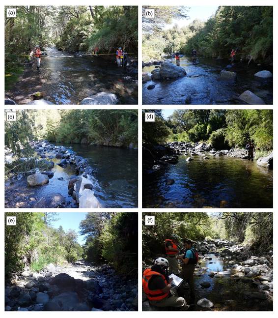
Figure 3 Photographs of the measurements: (a) Gauging 1; (b) upstream of the water diversion (Gauging 8); (c) at the intake and (d) downstream of the intake (Gauging 9); (e) an example of the first dry section of the river; (f) gauging at the first spring (Gauging 10).
In general, the measured streamflows exhibit a streamflow loss at almost all the measuring points. Only at point 5 is a streamflow increase observed. The losses and recoveries along the river are consistent with the described topography and geology in the study zone. As the lavas in the watershed have ages of less than 600,000 years, they have high permeability associated with young basalt (Yoshida and Troch, 2016) promoting the infiltration process. In addition, the gaugings were carried out in a zone associated with Atacalco lavas, which are situated above the Los Pincheira lavas and below alluvial deposits (Figure 4); therefore, these water losses and gains are due to the jointing presented by the Los Pincheira and Atacalco lavas documented by Dixon et al. (1999) and Naranjo et al. (2008).

As a complement, Figure 5 presents the result of the groundwater model, showing the interaction between the water level of the 14 700 m of simulated river (from springs 1 and 2 to point 13; Figure 2) and the topography of the longitudinal axis of the same stretch derived from the DEM. In the figure it is observed that the water level tends to be close to the surface between the spring sector (first boundary condition) and approximately point 12 (Figure 5), and then it undergoes a descent that it maintains until reaching ground level in the sector of the largest spring (gauging 13). A comparison of the results of the gauging campaign and the numerical model shows that the area in which the water level descends (Figure 5) coincides with the beginning of the second dry section of the river found in the field campaign (see second solid line in red in Figure 2). Therefore, it can be inferred that this section is disconnected from the aquifer, possibly because the infiltration rate (in this stretch) is greater than the surface flow of the river. Similarly, Figure 5 shows that in the spring zone (point 13) coincides with the representation of the water table and topography, owing to, as observed in the figure, the water table reaching ground level (see lower left corner of the figure).
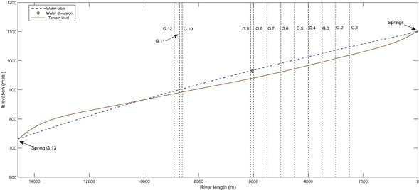
Figure 5 Result of the numerical groundwater model (dashed blue line) compared with the topography (solid brown line). The vertical lines indicate the location of each gauging along the river.
Based on the streamflow losses measured along the Renegado River, the springs observed at different altitudes that emerge from the fractured rock system, along with the results found by Arumí et al. (2014b) in the Diguillín River (associated with Los Pincheira lavas), suggest that the interaction between surface water and groundwater in the Renegado River watershed is potentially promoted by its geological and topographical relief characteristics. In addition, analyzing the streamflow measured at gauging 13 (greater than that estimated assuming hydrological similarity from gauging 1) suggests that: 1) there is a large water supply through the fractured rock and 2) the water losses from the surface probably originate upstream of gauging 1, reaffirming that there is possible exchange of surface water and groundwater along the river, driven by the topography and attributed to geological (volcanic) formations and fractured rock aquifers (Montgomery, Rosko, Castro, Keller, & Bevacqua, 2003). Similarly, the foregoing minimum streamflow. Therefore, it is recommended that at least one gauging campaign be carried out to verify the geological and topographic characteristics at a point to be studied in order to verify the assumptions or calculations that are made.
The geological characteristics, along with the observed interactions, have been identified in similar zones. For example, Zanon, Genereux and Oberbauer (2014) studied an area in the tropical jungle of Costa Rica, where they identified interactions between surface and groundwater. The authors describe that the geology of the studied area is influenced by volcanic processes, with highly permeable lavas present. Muñoz et al. (2016) mention that the dissimilar hydrological behavior in a watershed system located in south-central Chile is due to the special geological characteristics (associated with highly permeable lavas) and characteristics related to the topography of the volcanic complex where the system is located, which determine water transfers (results consistent with the bases described by Tóth, 1999). Considering that a common factor in these areas and the Renegado River is the presence of geological formations associated with highly permeable lava, it can be assumed that the geology promotes the interaction of surface and groundwater along the river, in addition to having a significant effect on the hydrological response of the watershed (Arumí et al., 2014b).
With respect to the differences between the measured streamflows and those estimated using hydrological similarity (see Table 1), along with the analysis carried out, the following question arises: Is it correct to assume hydrological similarity and apply the streamflow transposition model within a watershed or between watersheds of volcanic mountain geology in the low-streamflow or low-water period? In this context, the streamflow transposition method implicitly assumes the hydrological similarity concept. This method is widely used and applied by engineers, especially in streamflow prediction (maximums and minimums) in ungauged basins (Reed et al., 2006). In low-water periods, the streamflow that runs into the channel is controlled by the aquifer water release process. As the volcanic geological formations in the watershed favor groundwater recharge, movement and release (Parra, Arumí, Muñoz & Paredes, 2019), there is an important and complex interaction between surface and groundwater that is difficult to observe and quantify. Therefore, applying the hydrological similarity method in the low-water period can produce uncertain results. Thus, it is important to consider that there could be limitations on streamflow extrapolation in watersheds where there is limited knowledge of how far up- or downstream hydrological characteristics can be extrapolated in a river network (Poff, Olden, Pepin, & Bledsoe, 2006). It is crucial to consider the processes or factors that predominate in minimum streamflow generation in mountain watersheds, since not doing so could result in over- or underestimation of a minimum streamflow. Therefore, it is recommended that at least one gauging campaign be carried out to verify the geological and topographic characteristics at a point to be studied in order to verify the assumptions or calculations that are made.
Conclusions
The influence of the topography and geology of the watershed cause the Renegado River to "lose" water through infiltration in some areas and “recover” it in other areas. These water losses or gains are associated with the union of Los Pincheira and Atacalco lavas, which are highly permeable. This phenomenon promotes rapid groundwater movement that, combined with the topography, promotes the interaction of surface and groundwater along the river. Therefore, the topography and geology of the area are a determining factor in the hydrological behavior of the watershed.
It is important to stress that in practical engineering the assumption of hydrological similarity between basins is often used to estimate maximum or minimum streamflows in unmonitored watersheds. However, as demonstrated in this study, geology plays a fundamental role in the hydrological processes that predominate in these watersheds. Therefore, the application of the hydrological similarity assumption in low-streamflow (low-water) periods can give unsatisfactory results, such that in watersheds with a volcanic influence, this similarity must be analyzed and verified with complementary studies (e.g., geomorphological, land-use and geological studies).
Acknowledgments
The authors thank FONDECYT project 11121287, “Hydrological process dynamics in Andean basins. Identifying the driving forces, and implications in model predictability and climate change impact studies,” and CRHIAM (ANID/FONDAP/15130015) for supporting this research.
REFERENCES
Arumí, J. L., Rivera, D., Muñoz, E., & Billib, M. (2012). Interacciones entre el agua superficial y subterránea en la región del Bío Bío de Chile. Obras y Proyectos, 12, 4-13. DOI: doi.org/10.4067/S0718-28132012000200001 [ Links ]
Arumí, J. L., Oyarzún, R., Muñoz, E., Rivera, D., & Aguirre, E. (2014a). Caracterización de dos grupos de manantiales en el río Diguillín, Chile. Tecnología y ciencias del agua, 5(6), 151-158. Recuperado de http://www.scielo.org.mx/pdf/tca/v5n6/v5n6a10.pdf [ Links ]
Arumí, J. L., Maureira, H., Souvignet, M., Pérez, C., Rivera, D., & Oyarzún, R. (2014b). Where does the water go? Understanding geohydrological behaviour of Andean Catchments in South-Central Chile. Hydrological Sciences Journal, 61(5), 844-855. DOI: doi.org/10.1080/02626667.2014.934250 [ Links ]
Banks, E. W., Simmons, C. T., Love, A. J., Cranswick, R., Werner, A. D., Bestland, E. A., Wood, M., & Wilson, T. (2009). Fractured bedrock and saprolite hydrogeologic controls on groundwater/surface-water interaction: A conceptual model (Australia). Hydrogeology Journal, 17(8), 1969-1989. DOI: 10.1007/s10040-009-0490-7 [ Links ]
DGA, Dirección General de Aguas. (1991). Manual básico para instrucción de hidromensores. Santiago, Chile: Dirección General de Aguas. Recuperado de https://dga.mop.gob.cl/legistlacionynormas/normas/Reglamentos/proced_hidromensor.pdf [ Links ]
Dixon, H., Murphy, J., Sparks, M., Chávez, S., Naranjo, J., Dunkley, J., Young, P., Gilbert, S., & Pringle, J. (1999). The geology of Nevados de Chillán Volcano, Chile. Revista Geológica de Chile, 26(2), 227-253. DOI: doi.org/10.4067/S0716-02081999000200006 [ Links ]
Fan, Y., Toran, L., & Schlische, R. W. (2007). Groundwater flow and groundwater-stream interaction in fractured and dipping sedimentary rocks: Insights from numerical models. Water Resources Research, 43. DOI: doi.org/10.1029/2006WR004864 [ Links ]
Harvey, J., & Bencala, K. (1993). The effect of streambed topography on surface-subsurface water exchange in mountain catchments. Water Resource Research, 29(1), 89-98. DOI: doi.org/10.1029/92WR01960 [ Links ]
McDonald, M. G., & Harbaugh, A. W. (1988). A modular three-dimensional finite difference ground-water flow model. Virginia, USA: US Geological Survey. [ Links ]
Montgomery, E. L., Rosko, M. J., Castro, S. O., Keller, B. R., & Bevacqua, P. S. (2003). Interbasin underflow between closed altiplano basins in Chile. Groundwater, 41(4), 523-531. DOI: doi.org/10.1111/j.1745-6584.2003.tb02386.x [ Links ]
Muñoz, E., Arumí, J. L., Wagener, T., Oyarzún, R., & Parra, V. (2016). Unraveling complex hydrogeological processes in Andean Basins in South-Central Chile: An integrated assessment to understand hydrological dissimilarity. Hydrological Processes, 30(26). DOI: doi.org/10.1002/hyp.11032 [ Links ]
Naranjo, J., Gilbert, J., & Sparks, R. (2008). Geología del complejo volcánico Nevados de Chillán, Región del BioBío. Carta Geológica de Chile, Serie Geología Básica, Servicio Nacional de Geología y Minería. Recuperado de https://www.sernageomin.cl/wp-content/uploads/volcanes/01/carta-NevadosdeChillan.pdf [ Links ]
Parra, V., Arumí, J. L., Muñoz, E., & Paredes, J. (2019). Characterization of the groundwater storage systems of South-Central Chile: An approach based on recession flow analysis. Water, 11(11). DOI: doi.org/10.3390/w11112324 [ Links ]
Peiffer, Y., Taran, A., Lounejeva, E., Solís-Pichardo, G., Rouwet, D., & Bernard-Romero, R. (2011). Tracing thermal aquifers of El Chichón Volcano-Hydrothermal System (México) with 87Sr/86Sr, Ca/Sr and REE. Journal of Volcanology and Geothermal Research, 205(3-4), 55-66. DOI: doi.org/10.1016/j.jvolgeores.2011.06.004 [ Links ]
Poff, N., Olden, J., Pepin, D., & Bledsoe, B. (2006). Placing global stream flow variability in geographic and geomorphic contexts. River Research and Applications, 22(2), 149-166. DOI: doi.org/10.1002/rra.902. [ Links ]
Reed, P. M., Brooks, R. P., Davis, K. J., DeWalle, D. R., Dressler, K. A., Duffy, C. J., Lin, H., Miller, D. A., Najjar, R. G., Salvage, K. M., Wagener, T., & Yarnal, B. (2006). Bridging river basin scales and processes to assess human-climate impacts and the terrestrial hydrologic system. Water Resources Research, 42(7). DOI: doi.org/10.1029/2005WR004153 [ Links ]
Rubio-Álvarez, E., & McPhee, J. (2010). Patterns of spatial and temporal variability in streamflow records in South Central Chile in the Period 1952-2003. Water Resources Research, 46(5). DOI: doi.org/10.1029/2009WR007982 [ Links ]
Tóth, J. (1999). Groundwater as a geologic agent: An overview of the causes, processes, and manifestations. Hydrogeology Journal, 7, 1-14. [ Links ]
Wagener, T., Sivapalan, M., Troch, P., & Woods, R. (2007). Catchment classification and hydrologic similarity. Geography Compass, 1(4), 901-931. DOI: doi.org/10.1111/j.1749-8198.2007.00039.x [ Links ]
Yoshida, T., & Troch, P. (2016). Coevolution of volcanic catchments in Japan. Hydrology and Earth System Sciences, 20, 1133-1150. DOI: doi.org/10.5194/hess-20-1133-2016 [ Links ]
Zanon, C., Genereux, D., & Oberbauer, S. (2014). Use of a watershed hydrologic model to estimate interbasin groundwater flow in a Costa Rican rainforest. Hydrological Processes, 28(10), 3670-3680. DOI: doi.org/10.1002/hyp.9917. [ Links ]
Zúñiga, R., Muñoz, E., & Arumí, J. L. (2012). Estudio de los procesos hidrológicos de la cuenca del río Diguillín. Obras y Proyectos, 11, 69-78. [ Links ]
Received: June 01, 2018; Accepted: January 24, 2020
 Este es un artículo publicado en acceso abierto bajo una licencia
Creative Commons
Este es un artículo publicado en acceso abierto bajo una licencia
Creative Commons
