Introduction
World Health Organization recognizes dengue fever (DF) as the fastest spreading tropical disease across the world, with approximately three billion people at risk of contracting dengue virus.1 Different studies estimated more than 400 million cases of classic dengue and 500 thousand cases of dengue hemorrhagic fever registered, with mortality reaching 5% in the latter.2,3
Local climate and the El Niño-Southern Oscillation (ENSO) play a key role in the ecology and biology of mosquito vectors and the viruses they transmit, and consequently have a strong influence on the risk of dengue transmission.4,5,6,7,8,9,10,11,12,13,14,15,16,17,18,19
Precipitation changes may create larger or new habitats for mosquito larva, increasing vector populations.7,20,21,22,23 Ambient temperatures influence rates of mosquito larval development,24,25adult biting activity,26,27the gonotrophic cycle,28 and reduction of the extrinsic incubation period.29
ENSO has an influence on the global climate system, especially over the tropics, through inter-annual variations in atmospheric circulation, temperature and precipitation at different distant locations, which is termed teleconnection.20,30 These are the theoretical causal mechanisms linking ENSO with dengue in certain geographical regions.
It is generally understood that dengue is a climate-sensitive disease. However there are serious knowledge gaps in understanding the complex relationship between these teleconnections, weather, social factors and DF. This gap has continued to date and the factors that determine whether epidemic transmissions will occur are complex.
There is evidence that increase in air temperature, sea surface temperatures (SST), rainfall and ENSO have been associated with increased DF in some regions.5,6,15,31,32 Dengue transmission in warm and humid regions of México has been shown to be a strongly associated with ENSO and weather variables.8,9,12,14 Less is known about the relation with cultural and social factors (social backwardness, the lack of water access and the use of uncovered water tanks not using mosquitoes nets, the lack of health services and health education), which also play an important role in the prevalence of the disease.9,33,34 Also unplanned urbanization and inadequate resources for vector control are factors that promote transmission and are characteristic of poor countries. In México, Hurtado and colleagues found14 that these dengue control activities increased only after a rise in dengue cases. Reiter and colleagues35 studied dengue transmission on the Mexico-USA border and found higher rates in the Mexican city compared to the American one. Also, Brunkard and colleagues36 made a cross-sectional serosurvey in Brownsville, Texas, and its cross-border neighbor Matamoros, Mexico. Their results show that low income across both cities was the dominant risk factor for dengue infection, highlighting the importance of identifying and assessing the effects of social factors in analyses of inter-annual variability.
In 2005, the Mexican national rate of classic dengue morbidity was 16.3 per 100 000 inhabitants, however, in the state of Veracruz the rate was 53.5 per 100 000 inhabitants.37 The occurrence of epidemic classical dengue, hemorrhagic dengue and dengue shock syndrome in the Americas make this vector borne disease an important public health concern.
Study objectives
The aim of this study was to assess linkages between weekly incidence rate of dengue and climate variability adjusted by weather and social variables. We analyzed a larger geographical area compared to studies that focused on small areas by including data from 10 municipalities of the Olmeca region in Veracruz State and only considered sero-confirmed weekly dengue cases.
Materials and methods
Data
We used a negative binomial model (NBM) to evaluate the role of climatic and social variables on dengue incidence over a ten year period (1995-2005) using dengue cases, registered weekly by the health jurisdiction in ten municipalities with complete epidemiological and climatic data of the Olmeca region in the Veracruz state, during the 10 year study period.12,14,38,39
The Olmeca region is located in Veracruz State. It is the region with the highest surface area with 17 603.25 km2 and consists of 25 municipalities. According to the 2010 census, the region had a population of 1 194 392 inhabitants (15.69% of the total population of the State). The Olmeca region lacks basic services: 30.6% of homes lack water utilities, 20.69% lack sewage facilities, and 52.26% of households suffer from overcrowding.40
We compiled daily weather data for maximum temperature, minimum temperature and rainfall, from the most representative (in terms of geographical location, altitude, temperature and rainfall) meteorological stations in the region operated by the National Meteorological Service.41
Weekly records for sea surface temperature (SST-34) for the 3.4 Niño region (5S-5N, 170W-120W) were obtained from openly available databases of the National Oceanic and Atmospheric Administration42 of the United States Government.
The Unified Epidemiological Surveillance System (SUIVE) of the Health Ministry of the State of Veracruz43 provided weekly epidemiological information on dengue cases from 1995 to 2005. We calculated weekly maximum temperature (maxT), minimum temperature (minT) and total accumulated weekly rainfall (r) corresponding with weekly epidemiological dengue reporting. All dengue case reports were serologically confirmed by the state lab (Laboratorio Estatal de Salud Pública) in Veracruz, Veracruz, México.
We obtained municipal population and population density (number of inhabitants per km2 surface) data from the National Institute of Statistics and Geography (INEGI) for 1990, 1995, 2000 and 2005.44,45,46,47 Information about the index of social backwardness and marginality was obtained from the National Council of Evaluation of Social Development Policy48 and from the National Population Council,49,50 which incorporates indicators of education, access to health services, basic services, quality and housing space, and assets at home from the same years. We used a polynomial regression to interpolate the weekly population and social variables (homes with dirt floor and population density) of the study area during the period of analysis to take into account historical population and social variable trends based on data from 1995 to 2005, from the every five year points given by the national census of the region.
Statistical analysis
The first step of the analysis examined temporal trends and seasonal variations of dengue cases, social variables (backwardness index, illiteracy, crowded housing, homes without electricity and homes with dirt floor), weather variables (maxT, minT, r) and the climate variable (SST-34), interpolated to each week in each of the 10 municipalities analyzed. For each municipality we used a model with minT and r as weather variables, SST-34 as climate variable, homes with dirt floor, population density and municipal population as social variables for each Municipality.
In a second step, we determined a lack of temporal trend (Dickey Fuller unit root test)51 and we diagnosed serial correlation of Pearson residuals with autocorrelation and partial autocorrelation functions. We empirically reduced serial correlation by addition of lagged autoregressive Pearson residual terms to the series until the portmanteau Q statistic52 indicated no significant auto or partial autocorrelation in the adjusted series.
One of the assumptions of ordinary least square regression models, that the multiple observations of the dependent variable be independent of one another, is usually violated in time series.53 Knowledge of such correlation structures allowed us to determine an unbiased estimation.54
In a third step, we took into account different model assumptions and used penalized smoothing splines to seasonally adjust the model55,56 fitting the spline function to the original series of dengue cases. We used restricted polynomial distributed lag models to verify the influence of exposure of climate and weather variables over previous weeks on incidence of dengue, avoiding multi-collinearity or correlated covariates57 with orthogonal third-degree polynomials with up to 20 weeks of lag from SST-34 and 6 weeks of lag from minT and r, allowing weekly Incidence Rate Ratio (IRR) of dengue to be influenced by SST-34, minT and r over previous weeks. A distributed-lag model is a dynamical model in which the effect of a regressor x on y occurs over time rather than all at once.58 The most common application of the polynomial distributed lag is restricting the lag coefficients to lie on a polynomial function. This imposes smoothness on the coefficients, but allows for considerable flexibility in the shapes of the lag distributions that it permits.58
Negative binomial models (NBM) were better than Poisson models for all localities analyzed as indicated by the significant over-dispersion statistic and by the Akaike Information Criterion. All the models were adjusted by social variables (homes with dirt floor and population density).
Finally, the predicted population size weekly series was added to each model to adjust dengue cases for changes in population over the period. Statistical calculations were done using Stata 14 (Stata Corporation, San Antonio, TX, USA).
Ethics
This is a study of secondary data, the names of individuals with confirmed cases were randomly assigned to a numerical identifier to allow anonymity of cases in the region. The ethics committee of the Instituto Nacional de Salud Pública (National Public Health Institute) approved the conduct of this research.
Results
We assigned a representative meteorological station to each municipality using criteria of nearest geographic location, altimetry, temperature and precipitation (figure 1).
Climatic characteristics
The average maximum temperature recorded at stations for the municipalities located in the mountains was 30.4 to 33.6ºC, with temperatures up to 43.1ºC in municipalities at lower altitudes (<500 meters above sea level). Minimum temperature ranged from 9.8 to 14.2°C in all the municipalities. The highest cumulative weekly precipitation was found in the coastal municipalities and lowest in the central part of the study area (figure 2).
The highest SST-34 was recorded during the periods 1997-1998 and 2002-2003.
Dengue morbidity rates
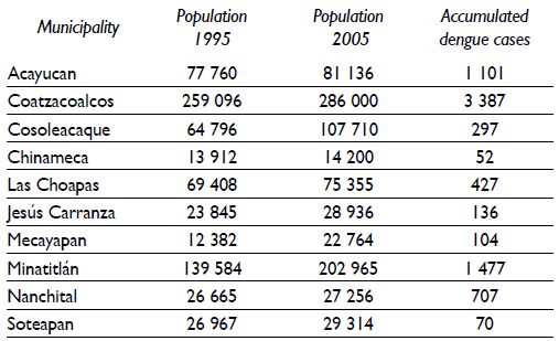
Dengue has been present in the Olmeca region from at least 1995 to 2005 (table I). The municipalities of Mecayapan and Coatzacoalcos showed the highest rates of dengue fever (above 200 cases per 100 000 inhabitants). However in the municipality of Jesús Carranza there has been a considerable decrease in the rate of dengue over the study time period (figures 3a-3c).
Table I Total population at the beginning and end of the study and accumulated dengue cases in municipalities of the Olmeca Region, 1995-2005. Mexico

Incidence Relative Risk (IRR) of weekly dengue cases
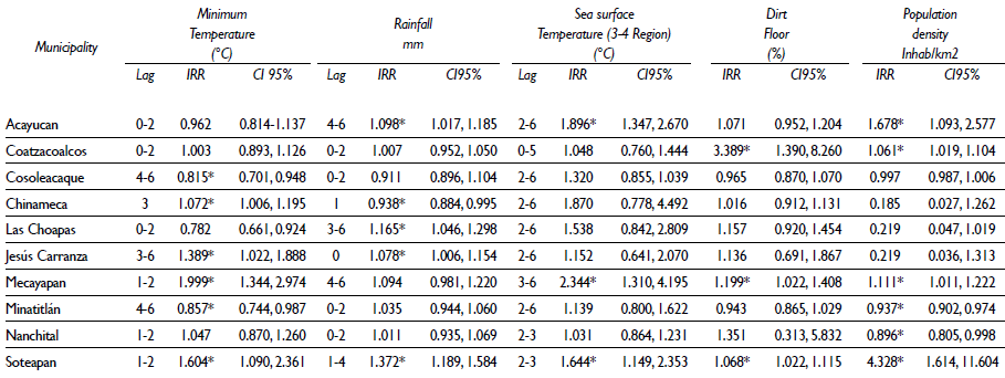
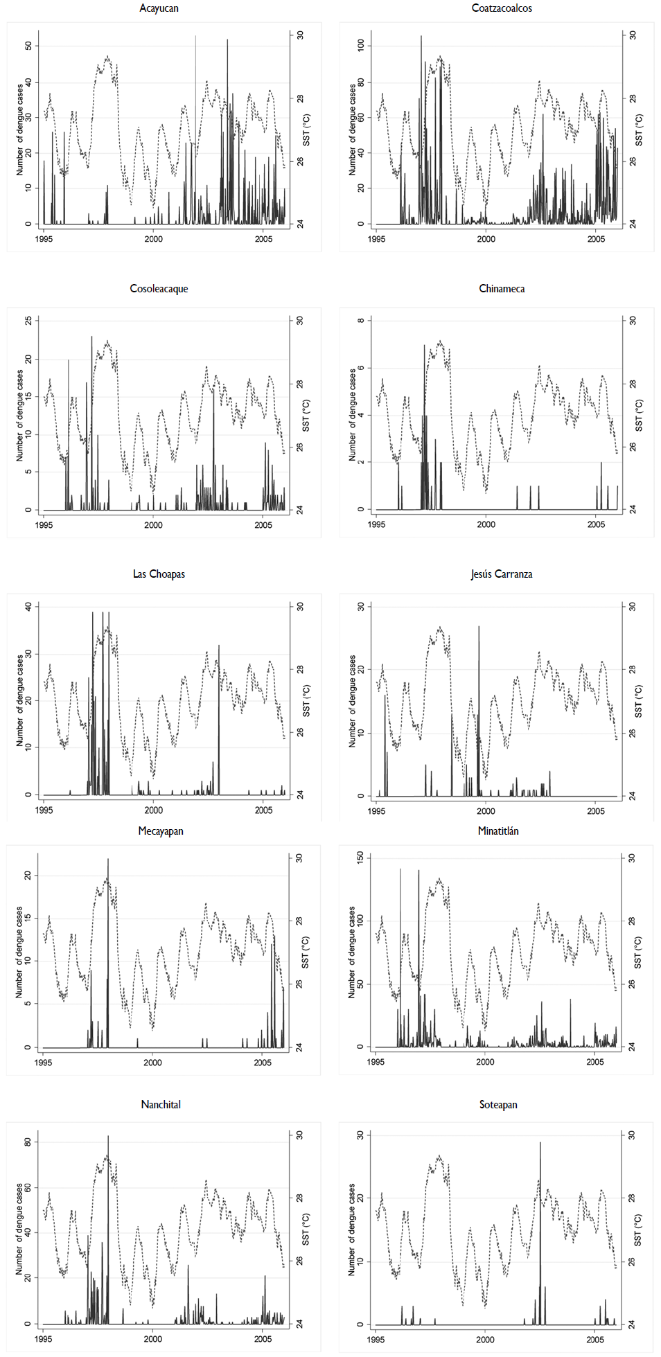
Analyzing the risk of dengue through NBM with distributed lags of minT, r and SST- 34 as explicative variables adjusted by population density, population and homes with dirt floor, we found that all the municipalities showed increased dengue cases per 1°C increase in SST- 34 with different distributed lags (between 0 to 6 weeks lag) (table II). However, only three municipalities had a significant increase: Acayucan shows an accumulated IRR of 1.89 (CI95%: 1.347, 2.670) over a 2 to 6 week lag; Mecayapan shows an accumulated IRR of 2.34 (CI95%:1.310, 4.195) over a 3 to 6 week lag and Soteapan an accumulated IRR of 1.64 (CI95%: 1.149, 2.353) over a 2 to 3 week lag. All the models were adjusted by weather and social variables. Time series were plotted for SST-34 and dengue incidence to observe their behavior and patterns of seasonal and inter-annual variability (figure 4).
Table II Incidence Rate Ratio of weekly dengue cases in ten municipalities of the Olmeca Region using weekly lags of climate and weather, along with social factors, 1995-2005. Mexico

* p<0.05
Lag= number of distributed week-lag
Note: All the models were adjusted by population

Figure 4 Time series of dengue confirmed cases in ten municipalities of the Olmeca Region and plots of Sea Surface Temperature anomalies (°C), region 3-4, during the period 1995 to 2005. Mexico
An increase in dengue cases for each 1% increase in homes with dirt floor was found in eight of the ten municipalities analyzed. Only three municipalities had a significant increase: Coatzacoalcos (IRR: 3.389, CI95%: 1.390, 8.260); Mecayapan (IRR: 1.199, CI95%: 1.022, 1.408) and Soteapan (IRR: 1.068, CI95%: 1.022, 1.225).
Discussion
Several of the municipalities in the study show sufficient rainfall all year to create year-round breeding sites. However dengue incidence is higher in municipalities with more population.
This finding corroborates previous studies in other world regions. For example, the strong association between weather variables and dengue found in Barbados at a lags of 6 to 16 weeks for vapor pressure and minimum and maximum temperature,58 the highest correlation with total rainfall a lag of seven weeks in Taiwan,59 and the strong positive association with absolute humidity in Thailand.33
Dengue incidence is sensitive to both periodic fluctuations and sustained changes in global and local climates, because vector biology and viral replication are dependent on temperature and moisture.3 Nonetheless, the already published associations between dengue incidence and weather variables were more or less strong, depending in the approach of analysis and the study areas.
In México, Colón-González and colleagues9 used multiple linear regression models to examine the associations between changes in the climate variability and dengue incidence in the warm and humid Mexican region. They demonstrated that dengue incidence was associated with the strength of El-Niño and the minimum temperature, especially during the cool and dry seasons.
Time series modeling approaches have been extensively applied in assessing the impact of climate variables on dengue incidence. For example Brunkard and colleagues12 use an auto-regressive model to evaluate the role of climatic factors on dengue incidence in one Mexican border city and found that weather and climatic factors together play a small but significant role in dengue transmission in that Mexican city. Hurtado-Díaz and colleagues14 used time-series analysis with auto-regressive models to examine the impact of SST-34 on probable cases of dengue in two municipalities of Veracruz State. They suggested that increases in SST (with 16 and 20 week-lag), temperature and rainfall were followed by increased dengue cases. In these examples, they do not include factors that impact dengue transmission like social and demographic changes, economic status, human behavior and education.
Our study differs from previous efforts in Mexico because we used a binomial negative regression model appropriate to the count nature of dengue cases. We also used distributed lags that allowed us to find differential lag effects following SST-34 that were statistically associated with increased dengue incidence. All models were adjusted for the distributed-lag effects of minimum temperature and rainfall and by social variables (homes with dirt floor, population density and total population).
In addition, we modeled weekly incidence aggregates instead of monthly. The temporal resolution of our models is higher than that used in other dengue studies, which is typically based on monthly data. This is very important because outbreaks of dengue occur quickly, and weekly data are more appropriate than monthly data, allowing faster capture fluctuations in the variable of interest.
In México, there are multiple factors that are associated with dengue, including uncontrolled urbanization with steadily increased human population and lack of adequate public services.48,49,50 We know that high levels of urbanization increase the risk of dengue.60,61
Also an inadequate water supply and sewage and solid waste disposal services increase the likelihood of water stagnation and offer potential breeding sites for the vector.7
The effectiveness of vector control, under-reporting of cases and immunity to the circulating serotypes,9 suggest feasible prediction on a municipal level, using statistical models that include weather, climate and social variables. The selection of the localities in the study and the lack of information about the circulating serotypes are limitations of this study. We need to incorporate longer time series and other important human related factors such as unplanned urbanization and dengue-infected human movement in modeling studies to determine the vulnerability of each municipality.6,15
Climatic factors do not, however, act in isolation, and social variables including population density, population growth, human movement and environmental changes have had far more to do with the global resurgence in dengue witnessed over recent decades than any direct effects of climate.9,53,62,63,64The influences of climatic and non-climatic determinants on current and future dengue transmission are very difficult to disentangle.65
In contrast to the results found by Brunkard and colleagues12 and Hurtado-Díaz and colleagues14 our analysis suggest that it takes environmental conditions approximately 6 weeks for SST-34, rainfall and minimum temperature, adjusted by homes with dirt floor, population density and municipal population to affect dengue incidence. That means the model may be used as early as approximately two months in advance to provide valuable information to decision makers about future epidemics.
However, we believe that the model can be used to report on vector control programs at national level, including preventive measures (taking special precautions to avoid being bitten by mosquitoes, keeping windows unscreened and doors closed, keeping window and door screens repaired, getting rid of areas where mosquitoes breed, such as standing water in flower pots, containers, birdbaths, discarded tires, etc.) and planning medical services based on the information of climatic variability, weather and social variables, for those who may be affected during future dengue outbreaks. Dengue, like all vector borne-diseases, is sensitive to climatic conditions which affect virus replication, vector development and survival, and therefore help define the geographical and seasonal limits that can support dengue-virus transmission.9,14,16,35,36,59,66,67,68,69,70
Conclusions
The challenge in refining models of dengue transmission to maximize their utility in predicting the location, magnitude and timing of future dengue epidemics or multiannual peaks in endemic cycles is to use data at appropriate spatial and temporal scales so that relevant ecological, social and demographic variables that operate at a local or regional scale can be adequately incorporated into the models.


 nueva página del texto (beta)


